|
Ripon to Bishop Monkton
|
Starting
point and OS Grid reference:

Canal basin off the B6265 Ripon
- limited free parking (SE
316709).
|
Ordnance
Survey Map
OS Explorer Map 299 - Ripon
& Boroughbridge.
Buy this map from
List
of OS Maps
Commission from map sales is
used to fund the website, so keeping it free to use.
| |
Distance: 6.6
miles
| |
Traffic light rating:

(For explanation see My
Walks page)
| |


For advice on .gpx files see
My
Walks page
|

Click
the PDF logo above to give a printable version of this walk without the
photos.
|
Introduction:
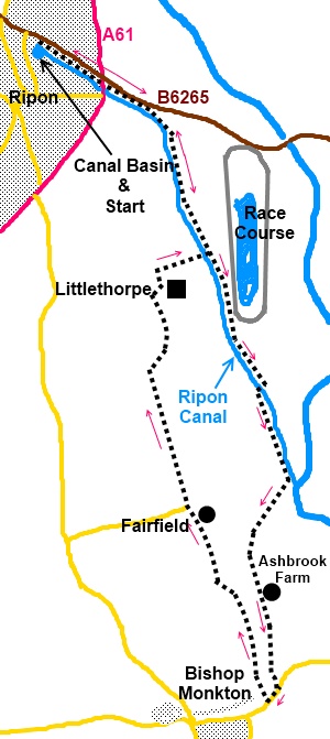
This is a lovely very easy walk
entirely on the level, from Ripon along the canal to the village of Bishop
Monkton with a stream running through its centre. The Ripon Canal and River
Ure Navigation runs for 10 miles from the centre of Ripon to Swale Nab where
the rivers Ure and Swale join to form the Ouse.
It is currently the northern most canal connected to the inland waterway
system. Planned in 1766 by John Smeaton also famous for building
lighthouses, it was abandoned in 1956 but successfully reopened to
navigation as far as Littlethorpe Road Bridge in 1986 and officially
re-opened in 1996 all the way back to the canal basin in the centre of
Ripon.
The walk takes in the 2¼ miles of the canal
to the point where it joins the Ure.
It starts at the canal basin where there is
limited parking (SE 316709). To get there, turn off the B6265 south-west on
to Bondgate Green Lane then immediately left on to Canal Road. If the
parking is full, park on Bondgate Green (the B6265).
Refreshments are available at two pubs in
Bishop Monkton and I can strongly recommend the Masons Arms which is hiker
friendly and where the food was truly great at modest cost. Check their
website for opening times.
Start:
From the canal basin follow the canal towpath. For the first half mile or so
the towpath follows the course of the B6265 but then, by the old lock
keeper’s cottage at a finger post indicating the Ripon Rowell Way, the
canal swings away from the road. Just by the locks (Rhodes Field Locks) are
two notice boards which give you the full story of the canal and information
about wildlife you might see.
Next you pass Bell Furrows Lock and the
marina. Cross the footbridge over the access canal to the marina and
continue along the towpath. On the next stretch you pass two bird hides
overlooking a large lake.
To
view route as a dynamic Ordnance Survey
map click
here.
%20Canal%20basin%20at%20Ripon.jpg)
%20Rhodes%20Field%20Locks%20and%20Lock%20Keeper's%20Cottage.jpg)
%20Canal%20Boats%20at%20Rhodes%20Field%20Locks.jpg)
Pass Ripon Racecourse on your left and then
Ripon Motorboat Club on the right. There is a stone bridge here
(Nicholson’s Bridge) note this, as it where you rejoin the canal on your
return journey. For now, continue along the towpath.
The next bridge in Renton’s Bridge (SE
331686). Cross this then turn left to follow the tarmac track. As this track
turns away from the canal (SE 331683), continue straight ahead alongside the
canal. The footpath is marked with a yellow footpath arrow.
At Oxclose Lock, the Ripon Canal joins the
River Ure. Just past the locks, go through the kissing gate (SE 332679) and
veer away from the canal at about 45 degrees. Ignore the trees now to your
left next to the canal and ahead of you very slightly left, in the
fence line, is a clump of trees/bushes
which forms the end of a hedge between the fields. Just to the right of this
is difficult to see wooden stile with a yellow footpath arrow. Cross this
and follow the line of the hedge. As the hedge line ends in the middle of a
large open field, keep straight ahead in line with the hedge passing just to
the left of a barn. You join a wide stony track and almost ahead of you is a
stile with a yellow footpath arrow. You may need to look either side of you
depending on exactly where you hit the track.
Once over the stile, follow the hedge line
towards the house. Go through the gate to the right of the house (Ashbrook
Farm - SE 330672) and keep straight ahead over the bridge, across the brook
and ahead on the broad track. The track opens into the main street of Bishop
Monkton. Turn right (SE 331666).
Keep a look out on the right for a row of red
brick cottages after about 100 yards. Immediately after them is West View
(SE 331665), which is your route back to Ripon. Note
that the sign for West View is not obvious as you approach from this
direction.
It is worth first having a look at the
village then returning to this spot. To find the genuinely excellent Masons
Arms, turn left along either along Main Street, following the stream or
better, continue along the road and turn left on St John’s Road to see a
fabulous topiary example. The pub is on the right after 200 yards or so.
%20Topiary%20at%20Bishop%20Monkton.jpg)
%20Stream%20running%20through%20Bishop%20Monkton.jpg)
Returning to West View, a few yards along it
the route goes off to the left through a walkers’ gate marked with a
yellow arrow.
Initially the footpath is fenced off from the
field. At the end of the fenced off section, continue straight ahead. The
footpath becomes a broad track. Follow this track until you reach a junction
of tracks and turn left, passing to the right of a large building which is a
huge hen house. It is likely there will be free range chickens everywhere!
Go through a metal gate and across the hen
enclosure then through another gate and bear left to follow the drive round
between the houses. As you get to the road, you pass an old “upright”
green footpath sign which confirms you have not been trespassing! Turn right
at the road (SE 336678).
Stay on the road passing through the village
of Littlethorpe. Note the long buildings of the Old Ropery where ropes would
have been made at one time. Continue walking along the road and turn right
at the junction just past the brick built St Michael’s Church (SE 323694).
%20St%20Michael%20and%20All%20Angels%20Church,%20Littlethorpe.jpg)
At the next bend in the road (SE 325694),
turn right down a broad track alongside a phone box and sign to the Ripon
Motorboat Club. You will see the white rails of Ripon Racecourse ahead. Keep
left as the track forks and go over the bridge across the canal to the
towpath. Turn left to retrace your steps to Ripon.
If you need to buy any
hiking equipment/clothing before your trip see the Hiking
Store
All information on this
site is given in good faith and no liability is accepted in respect of any
damage, loss or injury which might result from acting on it.
|


.jpg)
.jpg)
.jpg)