|
Pinhaw
Beacon
|
Starting
point and OS Grid reference:

Triangular
parking area on road at east end of Lothersdale (SD 961460)
|
Ordnance
Survey Map
OL
21 South Pennines.
Buy this map from
List
of OS Maps
Commission from map sales is
used to fund the website, so keeping it free to use.
| |
Distance: 3.4 miles
| |
Traffic light rating:

(For explanation see My
Walks page)
| |


For advice on .gpx files see
My
Walks page
|

Click
the PDF logo above to give a printable version of this walk without the
photos.
|
To
view route as a dynamic Ordnance Survey map click here.
Introduction:
This is a shortened version of
the “Lothersdale
Loop” walk, ideal for a couple of hours walk to Pinhaw Beacon and
back, where, for a modest climb to 388 metres, the views on a clear day are
probably some of the best in the area. I did the walk in the hope of
securing some better photos than on the Loop walk with moderate success.
The walk is easy enough.
Lothersdale is one of those places that is
almost a myth. It is not somewhere you go through on the way to anywhere
else and the chances are that if you arrive in Lothersdale, that’s where
you are going. It is not that easy to find. It is a tranquil untouched by
time sort of place. According to the oracle of Wikipedia, no house in the
village is connected to mains water. This has had the effect of limiting the
amount of development that has taken place.
The most straightforward way to get to
Lothersdale is from the A629 Keighley to Skipton Road. Turn off at the
roundabout on to the B6172. At the A6068 Colne Road turn right. Pass all the
shops than at a mini roundabout, turn right on to Wheatlands Lane. A
“through traffic” sign further on directs you on to Park Road. This
becomes Lothersdale Road. Follow the road signs to Lothersdale.
As you descend into the village just after a
left hand bend, look out for a large triangular shaped lay-by with a bench.
This is the best place to park.
Refreshment is available at the Hare and
Hounds pub in Lothersdale after the walk.
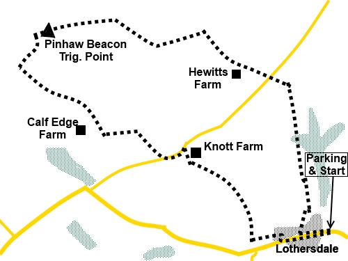
Start:
Walk down towards the village and just past the village hall, look out
for a finger post on the right indicating Public Footpath Pennine Way, White
Hill Lane ¾ of a mile (SD
959460). Take this path which leads via a walled lane to a gateway and turn
left signed Pennine Way. You in fact follow the Pennine Way until just after
Pinhaw Beacon.
Follow the fence line up the hill and then a
wall on the left crossing a small stile on the way. Continue following the
Pennine Way signs crossing a minor road (SD 957469) on to a concrete farm
track. Where this bends left, continue straight on through a gate.
Follow the wall on your left on to open
moorland passing some grouse butts. At the junction of paths on the moor
where there is a wooden post with
a “dogs not permitted” sign, follow the main track straight ahead to the
trig point at Pinhaw Beacon (SD 944472).
%20Summit%20of%20Pendle%20Hill.jpg)
%20View%20NE%20from%20Pinhaw%20Beacon%20to%20Skipton%20Moor.jpg)
From the trig point, take one of the paths
ahead (they meet a few yards on). At the corner of a wall with Pennine Way
signs, follow the direction which just says “FP”, effectively leaving
the Pennine Way (SD 943470).
%20View%20towards%20radio%20masts%20on%20Thornton%20Moor.jpg)
Arrive at a stile (3 steps over the wall),
turn right. Go over a small wooden stile after a few yards and turn left
indicated by a white arrow.
Over another stile, keep straight ahead
following the fingerpost for Lothersdale. The footpath leads down to a
tarmac track, which is the drive to Calf Edge Farm. Turn left here (SD
948466). Follow the drive along and at the junction turn right.
On reaching the road, turn left (SD 951465).
After rounding a bend in the road and going
down a slight dip, turn right on the public footpath for “The Fold ¼
mile” and “Rook Street ½ mile”, just before Knott Farm (or Knott
Barn, depending on which map you are using) (SD 953465). As the walled lane
enters the field, follow its left hand boundary. You will soon be looking
down on the village of Lotherdale.
%20Looking%20down%20on%20Lothersdale.jpg)
Go through one gateway. At the next gateway,
follow the wall round to the right, without going through the gateway. You
should now be heading downhill towards a row of terraced houses.
Go over a stone step stile in the bottom left
hand corner of the field, next to a gate, then turn left through another
gate (or you could use the gate instead of the stile) (SD 957460). Follow
the left hand boundary of the field.
After 50 yards or so, go left through a
gateway and immediately right to follow the right hand boundary of the
field. Turn right through the next gate walking behind a mill building
conversion. Follow the track as it curves right down to the road. Turn left
along the road back to the car.
If you need to buy any
hiking equipment/clothing before your trip see the Hiking
Store
All information on this
site is given in good faith and no liability is accepted in respect of any
damage, loss or injury which might result from acting on it.
|


.jpg)
.jpg)
.jpg)