
|
|
|
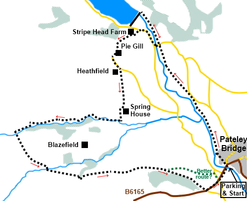
To view route as a dynamic Ordnance Survey map click here. Introduction: This walk, from the main car park in Pateley Bridge, where my Pateley Bridge to Brimham Rocks and Pateley Bridge to Dacre Banks walks also start. It explores part of the Nidderdale Way. It begins along the course of the River Nidd, for a look at Gouthwaite Reservoir. Unfortunately, you are not allowed to cross the dam, so then have to backtrack as short distance to Wath to cross the river. The route then takes you over the hill and along the course of Ashfold Side Beck and through the remains of Prosperous Smelt Mill before returning to Pateley Bridge. There are good views over Nidderdale in the process and a superbly sited bench for a picnic. Pateley Bridge, known locally as simply “Pateley”, is a lovely little market town with lots of small, independent shops, one of which claims to be the oldest sweet shop in England, selling sweets from jars in the traditional way. Choice of pubs too. If you have time, please pay a visit to the Nidderdale Museum, tucked away on King Street to the north of High Street. This really is a fascinating museum of local life with quite a tale to tell about life in the workhouse. It is run by volunteers and very reasonable! Check their website for opening times. The
route only skirts the attractive village of Wath, but it is worth a few
minutes diversion to wander through it. The Sportsman's
Arms Inn is a locally well known upmarket pub. The village also has the
remains of Wath Mill. This was originally a corn
mill which
converted
to flax spinning in 1816, a bobbin mill in 1840, and
reverted back
to oats,
barley
and wheat milling in 1859.
It has been restored and is open on selected dates. Check the Upper
Nidderdale Landscape Partnership website for details. Gouthwaite reservoir was constructed between
1893 and 1901, submerging the Elizabethan manor house of Gouthwaite White
Hall, which was rebuilt beside the reservoir with materials from the old
hall, and is Grade II listed. The reservoir is a “compensation
reservoir” to top up the River Nidd, when needed because Scar House and
Angram reservoirs further up the valley take much of the water to supply
Bradford. Gouthwaite is the only lake in England to contain grayling. The walk passes through the remains of Prosperous Smelt Mill, which, until 1889 had smelted lead ore from the nearby mine for almost 100 years. The Prosperous shaft is first recorded in 1781 but probably existed long before that. An information board tells you about it. Also in the area was Providence Mine and again you will pass an information board. A glance at the Ordnance Survey map will show that the Nidderdale Way runs along the North-East side of Gouthwaite Reservoir then along the road on the South-West side. If you are wondering why that route was not taken, the simple fact is that the two and a half miles of road walking involved is just too unpleasant because of the traffic up and down the Dale. Overall it is an easy walk with just a short steep climb up the field at Stripe Head Farm and an even shorter climb at the old mines. I have included an amber marking but it is marginal. The walk starts from Pateley Bridge, which is on the B6265, midway between Grassington and Ripon. There are public toilets opposite the main car park in Pateley Bridge where the walk begins. It is worth commenting that although the car park in Pateley Bridge is pay and display, it is reasonably priced. Start: Exit the car park, cross the road and turn right over the bridge. After a few yards, turn left to follow the Nidderdale way fingerpost. The footpath passes to the right of a house as the lane bends left. Initially, the path is fenced in but opens up. Continue until it divides and take the left fork to follow the river bank.
Cross straight over a path (which crosses a footbridge to your left) and continue to follow the river. You begin to follow a flat section, clearly the old trackbed for the railway built to aid the construction of the reservoirs. After going through a kissing gate, enter a large long field. The route leaves the old railway line and heads towards the river. You reach the road into Wath (SE 145677). To see the village turn right. To reach the Gouthwaite Reservoir dam, continue to follow the river for a further half a mile. Return to this spot and cross the river bridge. At the road junction, turn right.
Follow the road for a third of a mile but take care because as stated above, this is a busy road.
At Stripe Head Farm (SE 141680) turn left up its track, following a public footpath fingerpost for “Heathfield ½ mile”. Pass a stone barn on the right and just before you get to the farmhouse, go through the small walkers’ gate, in the corner, on the left and turn right through a farm gate. Follow the wall on the right to start with, then up the obvious path mor in the middle of the field.
Head up the field to the wall at the top and turn left, keeping the wall on your right, to the farmhouse (Pie Gill). There, you will find a gate with a yellow footpath arrow. Go through this and follow the drive to the road.
Turn left along the road for less than a quarter of a mile and turn off right at Heathfield, to follow the fingerpost for “Nidderdale Way”. Pass Leng House, which belongs to the Leeds Boys Brigade, a Christian faith based organisation similar to the Scouts, judging from their website. As the track bends sharply right, branch off left following the Nidderdale Way fingerpost and passing the bench I referred to in the introduction (SE 139671). There are super views over Nidderdale. Go through the left of the two gates ahead.
Follow the right hand boundary of the first field and after the next gate keep straight ahead across the next field. Follow the path down to the farm and go round it anti-clockwise. There are bridleway and Nidderdale Way markers to guide you. The path passes between the farmhouse and a barn, then follows the left hand field boundary. Drop down to the tarmac lane by the caravan site and turn right. When the lane splits, by the cattle grid at Westfield Caravan Park sign, fork left, through the campsite. Follow this broad track. It is actually a pleasant walk along here. After a mile, look out for a post (SE 119662) where a lesser path forks off left signed to “Upper Nidderdale”. Take this path. Descend to Ashfold Side Beck and cross the footbridge.
You are now at the remains of Prosperous Smelt Mill where there are various old heaps and building remnants to explore as you wish. The information board provides details about the place. However the continuation of the route is straight through the workings, i.e. straight ahead as you leave the bridge and climbing the hill.
The route turns right, round the last in the line of the pit heaps, soon passing a second information board. A blue bridleway arrow for the Nidderdale Way is attached to the side. At a junction of tracks, keep straight ahead. At the next junction where there are a number of bridleway fingerposts, take the right hand path heading downhill. Eventually the rough track becomes a tarmac lane, which you follow down to the road. Turn left to follow the road into Pateley Bridge. This is quite a busy road but you are only on it for a third of a mile. With hindsight, I wish I had taken the path off left, just before Eagle Hall (SE 147655) and followed the path across the fields to come out on a side road in Pateley but there you are. Either way, you will pass the Royal Oak pub which I can recommend for its beer! If you need to buy any hiking equipment/clothing before your trip see the Hiking Store All information on this site is given in good faith and no liability is accepted in respect of any damage, loss or injury which might result from acting on it.
| | |||||||||||||||||

.jpg)
.jpg)
.jpg)
%20View%20from%20riverbank.jpg)
%20Another%20view%20from%20the%20riverbank.jpg)
%20Gouthwaite%20Reservoir%20dam.jpg)
%20Gouthwaite%20Reservoir%20Dam.jpg)
%20Gouthwaite%20Reservoir.jpg)
%20View%20across%20Nidderdale.jpg)
%20View%20from%20the%20bench%20towards%20Peteley%20Bridge.jpg)
%20Looking%20along%20the%20Ashfold%20Side%20Beck%20valley.jpg)
%20Approaching%20the%20site%20of%20Prosperous%20Smelt%20Mill.jpg)
%20Remains%20at%20Prosperous%20Smelt%20mill.jpg)
%20Spoil%20heaps%20at%20Prosperous%20Smelt%20Mill%20site.jpg)