
|
|
|
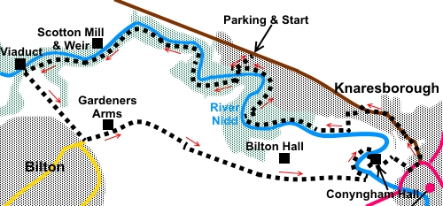
To view route as a dynamic Ordnance Survey map click here. Introduction: This Nidd Gorge and Old Bilton walk was a walk I had been intending to do for some time because looking at the Ordnance Survey (OS) map, it appears to be a natural circuit and an oasis of countryside close to major conurbations. It is an exceptionally easy walk, mainly through tranquil broadleaf woodland, containing a wide variety of trees. It will be particularly attractive in the autumn, with the autumn colours reflected in the River Nidd. The woodland is now under the care of the Woodland Trust. The route passes an attractive weir/mill setting at Scotton Mill a former flax mill, dating from 1798 and now a private house. The route visits a Victorian Nidd Gorge Viaduct (also known as the Bilton Viaduct), some 104 ft high, with seven arches and completed in 1848. It carried the North East Railway Line between Leeds and Thirsk and was closed in 1969. One of the elements which makes this an easy walk is because the section from the viaduct to Old Bilton and some way beyond is tarmac, being part of a Sustrans inspired cycleway from Knaresborough to Ripley. Unfortunately, this means you have to be very cycle aware, as they come up behind, with little sound on the tarmac and some do not have the smarts or consideration to sound their approach. At Old Bilton is the Gardeners Arms. This is a fabulous pub with a superb atmosphere inside and a large garden outside. It does not offer food as, with business logic, to which only they could aspire, Sam Smiths brewery who own it, ripped the kitchen out a few years ago on refurbishment! On the plus side, I was advised that walkers are permitted to consume their own sandwiches. Coupled with fantastic quality beer at ridiculously low prices, it is not such a bad arrangement, as long as you know. I didn’t! The route into Knaresborough leaves OS recorded public footpaths to make use of the Conyngham Hall Trail. This takes you into the attractive park and past the impressive Conyngham Hall. Built at the end of the 18th century, rather sadly, it became a business centre in 1995. The park has the usual collection of services found in larger public parks – games, café, toilets etc. The walk starts from the Woodland Trust car park situated just over a mile and a quarter north-west of the main traffic lights in the centre of Knaresborough, on the B6165. Follow the road sign from Knaresborough for Pateley Bridge. Start: Exit the car park (SE 330585) and turn left along the wide track and continue downhill, ignoring any turns off and passing an unusual bench which depicts historical uses of Nidd Gorge.
Arrive at two benches arranged in a ‘V’ shape, where there is a junction of tracks. Keep following the main track as it turns left. After a few yards, turn right down some steps to cross Burgess Bridge. A plaque tells you about the opening of the bridge in 1988 and that in 1995, the ownership of the land passed to the Woodland Trust.
Once across the bridge, turn right to follow the riverbank, following the fingerpost for “Nidd Gorge”. When the path forks, fork right following a yellow arrow. This is just to follow the river. It is a short diversion which joins the main path quickly, just before a stile, where you turn right. From then on, it is a case of following whichever path is closest to the riverbank.
At a gap in a fence, a blue bridleway arrow points left but ignore this (SE 316586). Pass the weir at Scotton Mill. The path bends left to join another path. Turn right at the junction.
The path emerges into a field; follow the right hand boundary to arrive at the Nidd Gorge Viaduct (SE 307583). At the viaduct, the old railway route is tarmac and is part of the Harrogate to Ripley cycle route. The views from it along the river Nidd are worth a look.
Turn left along the tarmac route to continue the walk and follow it until your reach a road (SE 314576).
Turn left, soon passing the Gardeners’ Arms. On this road you may meet a little traffic but this is minimal and most likely to be to/from a caravan site. Beyond the campsite is a gate which bars through traffic.
At SE 333572 you meet the drive to Bilton Hall. Keep straight ahead following a fingerpost for “Ringway Footpath”. Cross two small cattle grids and just after passing the second one and a walkers’ gate, turn left following a fingerpost for “Ringway Footpath” (SE 339573). After a few yards, fork left to follow the “Conyngham Hall Trail”, then left again at the next junction to follow the fingerpost for “Foolish Wood”. You now follow the river as it curves right, crossing by the bridge (SE 343575), then following the right hand path.
When it splits again, go to the left of the larger ruin section, passing the remains of the old piggeries. At the car park, turn left following a rising path. A notice soon tells you are on the way to tennis, golf, putting etc. At the tarmac lane, turn right. You will soon come to the gates on Conyngham Hall. Turn left through the gates and past the front of the hall.
Turn left just before the ice-cream kiosk then right along the tarmac path. At the Henshaws Art Centre, make your way through the car park to the road. Turn left to the traffic lights, then at the lights, left again along the B6165, following the road sign for Pateley Bridge. Unfortunately, you have to endure this busy road for just over half a mile. There are pavements but you will have to swap sides to stay on them. Turn left, just after the 40mph speed limit sign, down Lands lane (SE 341580). Follow Lands Lane as it turns right, then after about a hundred yards, immediately after a house called Beech Cottage, turn left down a narrow footpath between the hedges (SE 340579). It is easy to miss this (I did at first!). Follow it down to the river where it turns right. Now, simply follow the river. The path is obvious. At SE 330579, the path turns right up some rough wooden steps, to meet a broad track. Turn left here. You can soon descend to the river again, or stay on this broad track. Either way, continue until you see Burgess Bridge once more then retrace your steps to the car park.
If you need to buy any hiking equipment/clothing before your trip see the Hiking Store All information on this site is given in good faith and no liability is accepted in respect of any damage, loss or injury which might result from acting on it.
| | |||||||||||||||||

.jpg)
.jpg)
.jpg)
%20Track%20down%20to%20River%20Nidd.jpg)
%20Bench%20showing%20historical%20use%20of%20Nidd%20Gorge.jpg)
%20Burgess%20Bridge.jpg)
%20View%20from%20Burgess%20Bridge.jpg)
%20Reflections%20in%20the%20River%20Nidd.jpg)
%20More%20reflections%20in%20the%20River%20Nidd.jpg)
%20Weir%20at%20Scotton%20Mill.jpg)
%20Yet%20more%20reflections.jpg)
%20Nidd%20Gorge%20Viaduct.jpg)
%20View%20from%20Nidd%20Gorge%20Viaduct.jpg)
%20Flowers%20by%20the%20path.jpg)
%20Bench%20with%20sculptures.jpg)
%20Gardeners%20Arms.jpg)
%20Bridge%20at%20Conyngham%20Hall.jpg)
%20Conyngham%20Hall.jpg)
%20Bence%20near%20Burgess%20Bridge.jpg)
%20Burgess%20Bridge.jpg)