|
Greygarth
Circular
|
Starting
point and OS Grid reference:

Free
parking at Tom Corner (SE 179726)
|
Ordnance
Survey Map
OS
Explorer 298 - Nidderdale.
Buy this map from
List
of OS Maps
Commission from map sales is
used to fund the website, so keeping it free to use.
| |
Distance: 6.9 miles
| |
Traffic light rating:

(For explanation see My
Walks page)
| |


For advice on .gpx files see
My
Walks page
|

Click
the PDF logo above to give a printable version of this walk without the
photos.
|
To
view route as a dynamic Ordnance Survey map click here.
Introduction:
This walk in the Nidderdale Area of
Outstanding Natural Beauty, I call the Greygarth Circular. Well, I have to
call it something and it does encircle Greygarth, although Greygarth is
little more than a farm and a chapel. What inspired me to do the walk was
noticing “Greygarth Monument” and “Sighting Tower” during a casual
glance at the OS map, not to mention the prospect of a sunny day!
The walk is on the edge of Kirkby Malzeard
Moor, to the west of Kirkby Malzeard village itself. It is a quiet area and
I saw virtually no-one during the walk.
The Greygarth Monument started life as a
pointed tower built, unusually, in celebration of the extinction of wolves
from the area! Unfortunately, it blew down in 1890 but was rebuilt in 1897
to commemorate Queen Victoria's Diamond Jubilee. It obviously fell into
disrepair and was rebuilt in 1984. I have to confess to having slipped up,
in that when I turned off the road to climb by the monument, I was on access
land to the opposite side of the wall of the field in which it sits.
Expecting access somewhere along this wall, I was disappointed to find the
one gate, padlocked and inscribed with “private” signs. It appears it is
on private land and certainly no rights of way to it are shown on the map.
When I had a good view of the monument, I decided the view from where I was
would not be significantly worse than from the monument, which is not so
tall, so I pressed on. There may be access from another point.
The monument is a useful reference point as
it is visible during most of the walk.
The Carlesmoor Sighting Tower is a strange
construction and was evidently used with other “Colsterdale Towers” to
triangulate the end points of a water tunnel from Roundhill reservoir to
Harrogate.
There is some heather moorland walking, which
indicates the walk would be attractive in late summer especially. There is
also some road walking but the lanes hereabouts are quiet and you should
meet little traffic.
Here and there, are a number of mosaics set
into stones. I have since discovered these are to mark the circular
“Crackpot Trail”, devised by people from Kirkby Malzeard. By accident, I
find I followed most of this route. I have mentioned some of these mosaics,
where they help with directions.
Parts of the walk can be muddy so gaiters are
recommended after wet weather.
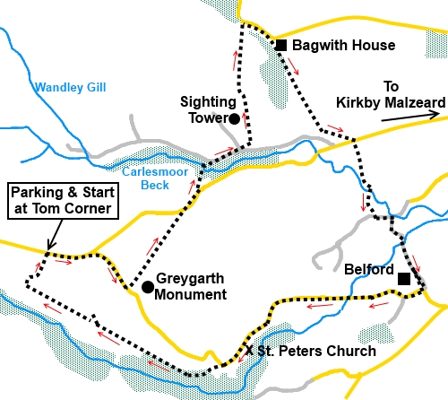
The walk starts from a car park at “Tom
Corner” and indeed, it is worth the trip there just for the fantastic
view. To get there, head west out of Kirkby Malzeard village (near Ripon)
along Main Street, following the signs for Laverton. About 200 yards after
leaving the village, turn right on the Kirkby Moor Road (signposted for
Dallowgill). Stay on this road for about three miles, crossing a cattle grid
on to the moor, until you reach a point at a farm where the road turns very
sharp left. If you go straight ahead on this bend along a road described as
unsuitable for motor vehicles (it is fine as far as the parking), the Tom
Corner parking is about ¼ mile on the right.
%20View%20from%20Tom%20Corner.jpg)
Start:
At the car park entrance, turn left to walk along the road (SE 179726). At
the junction, turn right in the direction of the road sign “Dallowgill 1¼
miles”. Pass and ignore a public bridleway sign on the left just past the
farm.
At a cattle grid, about a quarter of a mile
from the road junction, turn
left, before crossing, it to follow a wall on your right, climbing on to the
moorland (SE 184723). As you climb, you will get a good view of the
Greygarth Monument over the wall.
%20Greygarth%20Monument.jpg)
When the wall turns right, head for the left
hand side of the plantation of conifer trees you can see in the near
distance. The footpath route across the heather is not particularly clear
but just use the plantation as your guide.
%20View%20from%20near%20Greygarth%20Monument.jpg)
%20View%20to%20Kirkby%20Malzeard%20Moor.jpg)
As you get closer to the trees, you should
see a public footpath fingerpost by the road re-assuring you that invisible
as it may have been, there was (supposed to be) a footpath across the
heather.
Walk along the road over the cattle grid (SE
191732) (or use the gate alongside) and just before it turns a right hand
corner, take the concrete drive entrance on the left with a public footpath
fingerpost.
At the farmhouse, turn sharp right, through a
walker’s gate, then immediately through a five-bar gate and into the
trees. The path through the trees is easy to follow. It dips down to
Carlesmoor Beck before rising to a walkers' gate on to a farm track, where
you turn right (SE 192734).
%20Sun%20in%20the%20trees.jpg)
You pass the Potato House mosaic.
%20Mosaic%20of%20potato%20house.jpg)
The track forks at a farm (SE 194735). This
next bit of the route is not too obvious. You need to fork left here towards
the farm, running the gauntlet of some nasty looking noisy dogs either side
of the track but which thankfully are on short chains, so as long as you
stay in the centre you will be fine. Do not take the left turn between the
farm buildings but keep straight ahead, keeping to the right of the barns.
At the very end of the farm, turn left before
a metal gate, on to a broad walled track. There is a yellow footpath arrow.
You soon pass the unmistakeable Carlesmoor Sighting Tower, to your left.
%20First%20view%20of%20Carlesmoor%20sighting%20tower.jpg)
%20Side%20view%20of%20Carlesmoor%20sighting%20tower.jpg)
Stay on the track and at its end, go through
a walkers’ gate and follow the footpath to the right down to a stream.
Climb the other side to the top of the moor where there are some shooting
butts to your left.
Follow the narrow track through the heather
which forms a closing angle with the butts, eventually passing between two
of them. Some distance ahead of you is the ruin of Stocks Beck House. Head
for this (SE 194747).
You cross a plank bridge (re-inforced with a
metal plate when I passed), then turn right to the road and turn right.
In less than a quarter of a mile, you come to
Bagwith House. Turn right, just before it, down a track alongside the trees.
On reaching the field, keep straight ahead,
following the obvious route along the left hand boundary of the fields.
There are nice views along here over the Stocks Beck valley, along which you
walked at the other side and towards the Greygarth Monument and the Sighting
Tower.
%20View%20across%20the%20Stocks%20Beck%20valley.jpg)
%20Woodpecker%20mosaic.jpg)
%20Flag%20Iris%20and%20tadpole%20mosaic.jpg)
The track curves left, following the contour
of the land to a road. Turn left here for a few yards then right down a
narrow hedged track. The Woodpecker mosaic is at this point.
The track dips down to a ford but a
footbridge saves wet feet!
Follow the track as it swings left through a
gate (there is a public bridleway fingerpost here pointing right which you
ignore). There is also a mosaic of a cow on the corner.
Continue until you reach a right turn
indicated by a Ripon Rowel sign and a mosaic of a “yellow thing” (which
on post walk research I discovered is a flag iris and tadpoles – no
offence to the artist!) (SE 207730).
The track arrives at another ford with a
white footbridge (SE 208727), over the River Laver. Cross this and turn
right.
%20Ford%20and%20footbridge%20over%20river%20Laver.jpg)
%20Motorbike%20over%20river.jpg)
If you look at the OS map, there are a couple
of paths off to the right along here which would cut off a corner but I
think it is worth sticking with the main track because between the trees are
good view across to the North York Moors. The rough track changes to tarmac
at Low Belford Farm. Keep ahead to the road, passing Belford, an imposing
establishment with a lake in front.
%20View%20of%20North%20York%20Moors.jpg)
At the road, turn right (SE 204736).
You now have the longest stretch of road
walking, for about one and a quarter miles but it is a quiet lane. Almost at
the end of the road section, you pass St Peter’s Church (SE 195718).
Although it looks in good condition and the graveyard looks attended, there
are no signs at it and I believe it closed in 2011. An envelope regarding
electricity disconnection was in the porch, which might provide a useful
shelter.
When the road swings sharp right, heading
towards the Greygarth Monument, go straight ahead towards the old vicarage
(SE 192717). There is a public bridleway fingerpost indicating the route.
There are good views behind you here towards the NY Moors.
%20View%20and%20St%20Peters%20church.jpg)
As the drive to the old vicarage bends left,
cross a stile on the right. There is a blue bridleway arrow but ignore this
and keep straight ahead, passing a mosaic of rabbits.
At a wall, turn left indicated by a blue
bridleway arrow, then right almost immediately, along the edge of the woods.
There is an owl mosaic just by the gate.
%20Owl%20Mosaic.jpg)
Exit the wood by a walkers’ gate. Bear
round to the right to stay on the right of the ruined wall. Just round the
bend, there is another gate indicating the route.
As you pass a barn with a derelict building
alongside, the route is not too clear but follow the left hand boundary of
the field and you will see a wide track passing through the trees. Go along
here and through the gate on the right, at the end, just before a metal
gate. You will see the next walkers’ gate ahead.
A few hundred yards after passing a small
barn with a corrugated roof, come to a walled lane and turn right (SE
175724). At one time, this was the lane to the farm below you to the left
but is clearly no longer so used. Follow the lane as it dog-legs right in
front of a semi-derelict barn then left as it becomes nothing more than a
ditch, before becoming more recognisable as a walled lane again.
Turn right at the road and Tom Corner is
visible to the right.
If you need to buy any
hiking equipment/clothing before your trip see the Hiking
Store
All information on this
site is given in good faith and no liability is accepted in respect of any
damage, loss or injury which might result from acting on it.
|


.jpg)
.jpg)
.jpg)