|
Rosedale
Abbey to Lastingham
|
Starting
point and OS Grid reference:

Rosedale Abbey (SE 726960). Free car park on Heygate Bank – take the
turn signposted Egton Bridge.
|
Ordnance
Survey Map
OL26
North York Moors – Western area and the tiniest part of OL27 North York
Moors – Eastern Area (but see text).
Buy these maps from
List
of OS Maps
Commission from map sales is
used to fund the website, so keeping it free to use.
| |
Distance: 8.4
miles
| |
Traffic light rating:

(For explanation see My
Walks page)
| |


For advice on .gpx files see
My
Walks page
|

Click
the PDF logo above to give a printable version of this walk without the
photos.
|
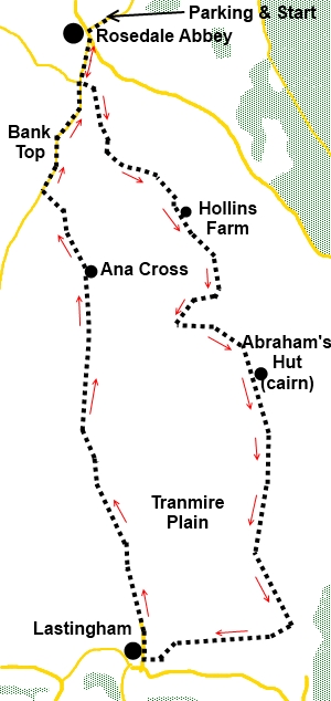
Introduction:
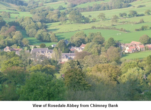
This walk takes you from the pretty
village of Rosedale Abbey with its history of Christian heritage, centuries
of farming and iron ore industry, to the equally picturesque Lastingham with
its ancient church (more information about the church can be seen on my walk
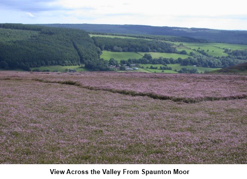
from Appleton-le-Moors). The outward route runs above the valley giving good
views of the Dale and the return (which is shorter) is more direct, across
the top of the moor, and past one of the best preserved of the many stone
crosses which are dotted across the North York Moors.
The walk starts in Rosedale
Abbey where there is street parking and a free car park, the starting point.
Refreshments are available at cafes/pubs in Rosedale Abbey and at the
Blacksmiths Arms in Lastingham.
Rosedale Abbey is at the
heart of the North York Moors and the best way to get there very much
depends on from which direction you arrive. It is best to consult an atlas
or get directions via Google Maps via my Location of Start Points via the “My
Walks” page.
The vast majority of this
walk is on map OL26 and I would not purchase OL27 for this walk alone as the
amount of the walk on it is tiny, just at the very edge.
Start:
From the car park, turn right. At the crossroads, turn left and walk to
the bridge over the River Seven. Cross the bridge ( SE 725958) in the direction of Hutton le
Hole and at the White Horse Farm Inn, turn left on the track which passes in
front of the pub (SE 724955). Continue along here (passing Holly Cottage)
for about ¾ of a mile and look out for a wooden bridleway fingerpost on the
right just before a farm (SE 732945).
To
view route as a dynamic Ordnance Survey map click here.
As you climb up on to the
moor, there are quite a jumble of paths. The description which follows is
not the most direct route to Lastingham but is designed to maximise the
views and to take you past the curiously named Abraham’s Hut cairn.
The path forks at a sign
indicating Access Land. Go right.
Climbing steadily, at a
crossroad of paths, go straight ahead.
When the path forks as you
approach the top of the moor go left.
On reaching a broad track and turn left, even
though this makes you feel as though you are going back the way you came –
there is an old quarry on the left here. On meeting another, go left and
stay on this track as it curves round to the right ignoring a left fork. You
will pass the large conical stone cairn to your left, which is Abraham’s
Hut (SE 739930), a scheduled ancient monument.
After almost 1.5 miles, as you approach a
wall (SE742908), take a right hand fork descending into a little valley.This
path becomes indistinct but as you descend into the little valley with its
stream, look out for the clear path rising to the right on the opposite
slope. Make your way across to it.
Climb this path to the gate
with a yellow footpath arrow and go through this and the small copse of
trees. When you get to the field, turn right and follow the right hand field
boundary.
From the end of this field,
the footpath passes across the centre of several fields. Landmarks in the
form of gates/stiles/markers are not particularly clear in some cases but
you should pick up sufficient in the centre of most.
Eventually you will cross a
stream via a two plank bridge (SE 732906) – and if these are damp, take
care, as I found to my cost they were very slippy!
Once across, bear left
there are a couple of waymarkers on posts indicating the way to a stile in
the left corner. Over this stile and you are in a “tunnel” of evergreen
shrubs. Follow this tunnel and the footpath exits via another stile and
stone steps into the road.
For the return leg to
Rosedale Abbey, turn right here. However, if you want to visit Lastingham
village first, turn left then right to see the church and/or to visit the
Blacksmith’s Arms. Return to this point afterwards.
%20St%20Marys%20Church%20Lastingham.jpg)
%20St%20Marys%20Church%20interior.jpg)
%20The%20Crypt.JPG)
At the end of the road, you
enter the moor via a gate. Go straight ahead indicated by a public bridleway
fingerpost.
The route is now
straightforward. Continue straight ahead, passing a four way fingerpost –
your direction is for Rosedale Abbey. Ignore a turn to the right.
At the next fork, go left.
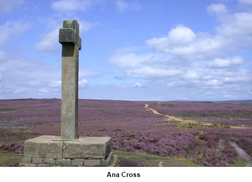
After passing Ana Cross (SE
725938), at a ‘T’ junction of paths, turn left.
You reach the road by a
lay-by where there is a notice board telling you about some of the history
of the iron-stone mining in the area. Turn right and walk down the famously
steep road back into Rosedale.
If you need to buy any
hiking equipment/clothing before your trip see the Hiking
Store
All information on this
site is given in good faith and no liability is accepted in respect of any
damage, loss or injury which might result from acting on it.
|


.jpg)
.jpg)
.jpg)