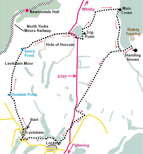
|
The
Hole of Horcum and Malo Cross
|
Starting
point and OS Grid reference:

Levisham
village (SE 833906)
|
Ordnance
Survey Map
OL27
North York Moors – Eastern Area.
Buy this map from
List
of OS Maps
Commission from map sales is
used to fund the website, so keeping it free to use.
| |
Distance: 10.2 miles
| |
Traffic light rating:

(For explanation see My
Walks page)
| |


For advice on .gpx files see
My
Walks page
|

Click
the PDF logo above to give a printable version of this walk without the
photos.
|
To
view route as a dynamic Ordnance Survey map click here.
Introduction:
The Hole of Horcum is a dramatic
natural feature adjacent to the A169 en route to Whitby from the south. As
the name perhaps suggests, it is a huge natural amphitheatre in the
landscape caused by the gradual wearing away of limestone layers by the
action of springs. This walk takes you along part of the rim of “the
Hole”, past some ancient (though difficult to spot earthworks) and
incorporates spectacular views across the North York Moors. As a bonus,
we pass the ancient Malo Cross and visit the site of standing stones –
though do not get too excited as only one stone seems to be still standing
plus a possible second which has been a gatepost!
This is a very easy walk on
well defined tracks/paths with very little gradient involved.
The walk starts at the
Horseshoe Inn in the village of Levisham. To get there, turn west off the
A169 about 5 miles north of Pickering for Lockton and continue through this
village on the dead end road signposted Levisham. Parking is on the road in
the village and in particular there is space on the left close to the pub
where there is a bench to change into your boots.
%20Horseshoe%20Inn%20Levisham.jpg)
Start:
Facing the front of the pub, take the road down its right hand side.
Follow the tarmac road to its end then the track to a gate. There is a three
way fingerpost there. Follow the direction of the fingerpost for Saltergate.
The track soon forks – go right.
The track descends gently
to a five way fingerpost. Bear right heading for Saltergate (ignore the
fingerpost here for the Hole of Horcum). Shortly after passing Dundale Pond
(SE 829919), the track forks, the right hand fork going to a small valley.
Keep left.
%20View%20Across%20to%20Hole%20of%20Horcum.jpg)
%20Dundale%20Pond.jpg)
Stay on the obvious broad
track and As you walk, keep a look out on the left for two small plaques,
the first telling you about an Iron Age dyke and the second (some distance
after you after you pass Seavy Pond (SE 833935) about some Bronze Age
barrows. The Hole of Horcum begins to open up to your right.
%20Hole%20of%20Horcum.jpg)
As you approach the A169,
to the left you will see the somewhat menacing monolith of the RAF
Fylingdales missile early warning station to the left.
%20RAF%20Fylingdales.jpg)
On reaching the A169 (SE
849941), follow the footpath alongside the right of it as it circles the
Hole for a short distance. As it forks by a blue bridleway arrow, go left
and up to the A169. Go straight across and take the tarmac track opposite
(SE 853939) signposted by fingerpost Crosscliffe 4 miles.
Just before the gateway to
Newgate Foot Farm, turn left at a three way fingerpost (SE 854938) along a
bridleway next to the trees. Halfway along the field to your right, you
should see by the far boundary a trig point which is shown on the OS map at
SE 855940.
You come to a gate on the
right with a blue bridleway arrow just before a wooden stile (SE854942). Go
through this gate initially straight ahead then bearing left as the path
follows the edge of the escarpment. As you come opposite RAF Fylingdales,
the path starts to descend gently to Malo Cross (SE 867950).
%20View%20across%20the%20tabular%20hills.jpg)
%20Malo%20Cross.jpg)
%20Blakey%20Topping.jpg)
By the cross is a
fingerpost and you want the direction for Newgate Foot, the right turn at
the cross (the lower level right turn not the one which goes up the hill).
Follow the path towards the plantation and follow the line of its fence. On
the left is the strange conical hill of Blakey Topping which looks totally
out of context.
Follow the fencing along
until it reaches a five bar gate Through this at the opposite side of the
field is a stile (SE 868934) and after crossing it, turn left to Newgate
Farm [see footnote]. Go through the farmyard and follow the track in the direction of
Blakey Topping as it follows the boundary of the plantation. At the top of
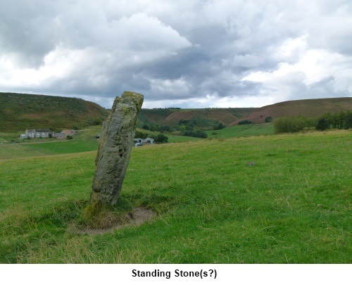
the field, turn right and after 150 yards, you arrive at the standing stones
site (SE 872934). Only one clear standing stone remains with another
possibility obviously having been a gatepost at some point. There are
another couple of stones lying down on the job!
Retrace your steps through
the farmyard and follow the concrete farm track as it climbs.
The next turn is difficult
to spot as it is not marked, so concentrate! Just after you reach the top of
the rise on the farm track, just after a bridleway sign, look out for a
metal gate in a corner set back a little from the concrete track (SE
864934). Go through this gate and follow the left hand field boundary. There
was a windsock in the middle distance at the time of my visit and you should
be almost heading towards it.
You are following a route
of “other public access” indicated by round green dots on the OS map.
Follow the track straight ahead to the main road (A169) (SE 852913). Here
you have a choice. a) to walk almost half a mile along the busy main road or
b) turn immediately left along a signposted footpath and walk two sides of a
small triangle through fields, adding perhaps ½ mile to the walk. Given
that this is a very busy and fast main road, I opted for the latter and
would recommend you do the same.
Assuming you do, turn
immediately left over a ladder stile. Go over another stile (bearing a
warning sign about cows with calves possibly being aggressive – but I
would not worry unduly about this just approach sensibly – see page on
Safety). About halfway along the field is a gate on the right. Go through
this, turn left and follow the left boundary of the field to the bottom and
turn right in the direction of the fingerpost for David Lane.
Follow the yellow footpath
markers and at a gate ignore another fingerpost for David Lane and continue
straight ahead to the main road, passing an old limekiln on the left.
Turn left (ignoring the
fingerpost towards Warren House Farm) and walk along the right hand verge of
the A169 for a mere 100 yards or so. Turn right at the small public footpath
sign (opposite a rough lay-by) into the trees (SE 850907). Keep more or less
straight ahead until you reach a three way fingerpost
and turn right for Levisham (SE 846900). If you have followed the
footpath strictly as shown on the map which sticks closer to the trees than
the obvious path on the ground, you might miss this fingerpost (which will
then be up to your left) but worry not. Look out for another fingerpost in
the shady hollow at the end of the trees (SE 845903) and turn right to
follow its direction. If approaching this fingerpost from the first one,
your route will be straight ahead.
Follow the main track
through the trees and through a metal gate, turn right across a footbridge.
There is a short section of wooden decking after the bridge.
The footpath exits the
trees into the road. Turn right and walk the short distance into Levisham. A
refreshing pint awaits at the very pleasant Horseshoe Inn which at the time
of my visit had my favourite pub notice displayed – “Bar open all
day”!
Footnote - It was reported to me that
following exceptionally heavy rains in 2019, the passage through the fields
to Newgate Farm was made impassable by a fast flowing stream. You may
therefore like to bear recent weather in mind before attempting this walk.
If you need to buy any
hiking equipment/clothing before your trip see the Hiking
Store
All information on this
site is given in good faith and no liability is accepted in respect of any
damage, loss or injury which might result from acting on it.
|


.jpg)
.jpg)
.jpg)