|
Wycoller
to Boulsworth Hill and Lad Law
Starting point and OS Grid reference:

Free
car park at Wycoller (SD 926395)
|
Ordnance Survey Map
OL
21 South Pennines – Burnley, Hebden Bridge, Keighley and Todmorden.
Buy this map from
List
of OS Maps
Commission from map sales is
used to fund the website, so keeping it free to use.
| |
Distance: 8.6 miles
|
Date of Walk: 25
October 2013
| |
Ascent:
Descent:
See Walking Time Calculator
|
1748ft (533m)
1747ft (533m)
| |
Traffic
light rating: 

(For explanation see
My Walks page)
| |


For advice on .gpx files see
My
Walks page
|

Click
the PDF logo above to give a printable version of this walk without the
photos.
|
To
view route as a dynamic Ordnance Survey map click here.
Introduction:
This walk to Boulsworth Hill and its
summit, Lad Law, starts from the very pretty hamlet of Wycoller in
Lancashire. Wycoller’s origins can be traced back to 10,000 BC or more,
originally agricultural, then moving to weaving in the 18th
century. The valley narrowly avoided being turned into a reservoir in the
late 19th century but following local outcry, an alternative
water supply was found. The then Water Board retained ownership until the
early 1970s, when Lancashire County Council bought it and created a country
park so preserving Wycoller.
The hamlet contains the impressive remains of
Wycoller Hall, which has a massive fireplace and alongside it, an unusual
keyhole shaped recess. The hall was built in the 16th century and
is said to be the inspiration for Ferndean Manor in Charlotte Bronte’s
Jane Eyre.
Alongside the hall is Aisled Barn, now an
information centre. This was built in 1630 and is impressive for its
magnificent Cruik beams. Do not miss it.
Along the valley are some great bridges, not
least the Clam Bridge which is made of a huge single stone.
Looking down on the hamlet is The Atom, a
panopticon sculpture from which there are good views of the valley and
Boulsworth Hill. To reach The Atom is but a short walk up the old coach
road, a clear path from the back of the Aisled Barn – just over a quarter
of a mile. If you go to look, note the ancient slab rock field boundaries.
Return to Wycoller to continue the walk.
%20The%20Atom.jpg)
%20View%20from%20Inside%20the%20Atom.jpg)
%20View%20from%20Near%20the%20Atom.jpg)
After leaving Wycoller, the walk route is
straightforward and easy to follow. There is a bit of a climb up Boulsworth
Hill to the Lad Law summit - about half a mile, earning an amber traffic
light but nothing too severe. It is a “figure of 8” route, so a shorter
walk could be done by omitting the second loop to Boulsworth Hill.
There are no refreshment opportunities en
route, other than at the tea rooms at the Wycoller Craft Centre but
some good rocks on which to perch at Lad Law whilst you munch your
sandwiches.
The walk starts from the car park at
Wycoller. To get there, take the B6250 off the A6068 to the east of Colne
where there is a brown tourist sign for “Wycoller Country Park 2 miles”.
Follow the signs from there. There is another car park at the Atom if
preferred which is accessed via the road opposite the Emmott Arms at
Laneshaw Bridge. This also has a brown tourist sign for “Wycoller Country
Park 2 miles”.
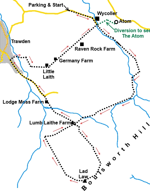
Start:
From the car park at Wycoller (SD 926395), turn right to walk along the
little footpath alongside the road then the road itself, turning right as
you cross the stream, until you get to Wycoller Village. Go left over the
packhorse bridge to see the ruin of Wycoller Hall, the visitors centre set
in an old cruik Aisled Barn.
%20Packhorse%20bridge%20at%20Wycoller.jpg)
%20Wycoller%20hall.jpg)
%20Old%20fireplace%20Wycoller%20Hall.jpg)
%20Aisled%20Barn.jpg)
Behind the visitors centre, is the old coach
road, which gives the option to climb to see the Atom, a panopticon (a
structure from which there are views in all directions). Return to the
hamlet to continue the walk.
With the hall at your back, turn left to
follow the broad track to the left of Wycoller Beck. Pass the iron age Clam
Bridge, a single slab of stone believed to be previously a
standing stone.
%20Clam%20Bridge.jpg)
Come to a four-way fingerpost (SD 937388 )
and take the track straight ahead following the concrete track to Dene House
Farm – part of the Bronte way. Go straight through the farmyard, ignoring
the path off to the left.
Follow the track through the field, with the
wall on your right. When the wall bends to the right, keep straight ahead up
the hill, guided by a yellow footpath arrow. At the top of the field, go
through a kissing gate and turn right (SD 942381).
Cross a stream via a wide bridge and climb
the hill at its far side, turning left to follow the fingerpost for the
Pennine Bridleway and Thursden Valley. The path crosses the moor and
sections of it are paved with stones.
On reaching a road, keep straight ahead,
still following “Pennine Bridleway” and “Thursden Valley 2½ miles”.
On reaching a gateway by a barn at Lumb
Laithe farm, turn left (SD 928369). There is a small sign on a post for
“Boulsworth Hill Circular Walk”. This section of path is shown on the
1:25000 OS map by a brown dotted line indicating a permitted bridleway (as
opposed to a Right of Way). Follow the concrete track as it climbs to a
covered reservoir. When you get to this, the route goes to its left.
%20Approaching%20the%20plateau.jpg)
You reach the plateau by a collection of
large rocks (SD 934361). Turn right (203° magnetic) for the white trig.
point which should be visible on the horizon. At the trig point (SD 930356)
are a few flattish stones where you can sit to eat your sandwiches, whilst
enjoying the good 360° views.
%20Lad%20Law%20trig%20point.JPG)
From the trig. point, follow the obvious
descending footpath (271° magnetic) which bears slightly right. Pendle Hill
is ahead of you, slightly left, on the horizon. You drop down for almost a
mile to join a broad track (SD 921367) which is the Pennine Bridleway once
more. Turn right.
%20Pendle%20Hill.jpg)
Stay on the track for about half a mile. You
pass the end of the concrete track you ascended to the reservoir and a mere
50 yards or so beyond this, turn left over a stone stile (SD 928370), then
bear slightly left. Follow the left hand boundary of the field and at the
bottom of the field, go over a stile and follow the path as it passes along
a depression (“valley” would be a bit OTT!).
The path comes down to a concrete bridge (SD
922373) over the stream but if you wand to deviate left here, for only 25/30
yards, there is quite an attractive waterfall, Lumb Spout.
Return to and cross the concrete bridge.
Follow the track to Lodge Moss Farm, going through the farmyard to the right
of the house. On reaching the tarmac road
(SD 921376), keep straight ahead, downhill.
You arrive at the attractive village of
Trawden. We do not venture too far into it – about 0.3 of a mile. Look out
for a cobbled area to the right (SD 913384), which is the bus terminus
(opposite Lane House Farm). Turn right and descend the cobbled track. At the
start of this, is a short section of rail from the old tram system, which
was in existence from 1901 to 1934.
Walk down the cobbles. You are looking for a
footpath on the right, about 30 yards from the tram rail and which is easy
to miss. It is just after the driveway to a bungalow and alongside a hedge.
There is a stile with a footpath arrow which takes you into a field.
Continue to follow the line downhill crossing the stream at the bottom via a
footbridge.
Keep to the left hand boundary of the next
field and climb the short hill through the trees. Go through a walkers' gate
and between the farm buildings (SD916385) and follow the drive. After
crossing a cattle grid, at the bend, take the footpath off to the left,
through the small gate.
Follow the right hand boundary of the field,
go through the gate by the farm (Little Laithe), then turn left (SD 922383).
It is now more or less a straight line back to Wycoller.
At the next farm (Germany Farm) go left to
follow its drive. As the drive bends sharply left, keep straight ahead to
follow the wall on the right. Cross a little wooden bridge and go over a
wide stile and keep to the right hand boundary of the field. Ignore the
footpath arrow indicating a path off to the right. You pass Raven Rock Farm
and cross another wide stile.
The path passes through a narrow wooded area.
Keep straight on here and ignore any other paths off. The path descends into
the valley. After descending some steps, join a tarmac lane and turn left.
You soon get back to Wycoller by the clapper
bridge. Turn left back to the car park.
If you need to buy any
hiking equipment/clothing before your trip see the Hiking
Store
All information on this
site is given in good faith and no liability is accepted in respect of any
damage, loss or injury which might result from acting on it.
|


.jpg)
.jpg)
.jpg)