|
Whitendale
and Baxton Fells
Starting point and OS Grid reference: 
Village of Slaidburn - pay and display car park
(SD 714524).
|
Ordnance Survey Map
OL41 Forest of Bowland.
Buy this map from
List
of OS Maps
Commission from map sales is
used to fund the website, so keeping it free to use.
| |
Distance: 12.1 miles
|
Date of Walk: 19
August 2011
| |
Ascent:
Descent:
See Walking Time Calculator
|
2047ft (624m)
2047ft (624m)
| |
Traffic
light rating: 

(For explanation see
My Walks page)
| |


For advice on .gpx files see
My
Walks page
|

Click
the PDF logo above to give a printable version of this walk without the
photos.
|
To
view route as a dynamic Ordnance Survey map click here.
Introduction:
This walk is a combination of clear
broad tracks and open moorland. As always but especially for this walk, you
need a clear day to get the benefit of good views and to avoid the
possibility of getting lost especially across Dunsop Fell on the return leg.
Familiarity with map reading and compass use are advisable in case
visibility deteriorates. The walk is also best done after a dry spell as
there are many boggy areas. Gaiters are recommended.
The route follows part of
the Whitendale River and in its valley you have a good chance of seeing
various birds of prey, especially in spring.
The walk starts from the
modestly priced pay and display car park in the lovely village of Slaidburn
in the Trough of Bowland where there are public toilets. The best way to get
there depends very much on from which direction you are coming so it is best
to consult an atlas or my Google
Map.
Refreshment is available at
the Hark to Bounty Inn in Slaidburn.
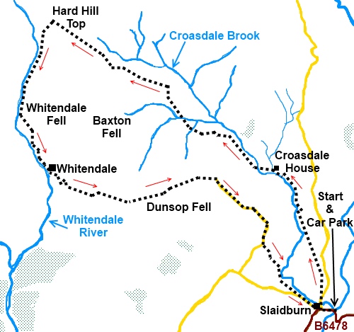
Start:
From the car park at Slaidburn, turn right along the road and right at
the war memorial in the centre of the village. Go across the old road bridge
and walk along the road. Turn left off the road after about 200 yards over a
stone step stile by a footpath finger post.
Climb up the hill - do not
go right through the obvious gateway at the end of the wall. In the top
right hand corner of the field after passing through the trees, go over the
step stile.
%20Looking%20West%20to%20Burn%20Fell.jpg)
Follow the wall on the
right in the next field. Just after the wall ends, bear off to the left.
Walk diagonally across that field, go over a stone step stile at the end of
it and carry on straight ahead over the next field.
Go over a wooden stile and
straight across the next field. Over the next stile, you cross a broad farm
track and go straight ahead. As the field dips down, go over another stone
step stile.
Walk across this next field
to a stream and turn right and follow it along to a wooden step stile. Over
this stile, go straight ahead and to the corner of the field keeping the
stone barn to your right.
Go through the metal gate
and straight across the farm track and through the kissing gate opposite. At
the far end of the field go over the wooden stile with the yellow footpath
marker. In this field whilst walking straight ahead, drift gently across to
the right and the higher part to meet a broad track. Turn left.
As the path forks to go
into the farm yard, keep left. Continue on this track and go through a farm
gate between a farmhouse and barn and almost immediately afterwards, turn
left across a ford.
Follow the fence line along
and turn left through a kissing gate, descending to the little valley. Cross
the wide bridge at the bottom and follow the obvious track bearing right.
Follow the track along and go left through a kissing gate where there is a
notice telling you that you are entering “Access land”.
Climb the short steep hill
and follow the path round to the right. The path here is indistinct but
basically just follow the course of the stream below. Look out for posts
with yellow tops which mark the route of the path. If you follow the stream
along, sooner or later you will see one.
Cross a series of wooden
“duckboards” and the path climbs gently away from the stream to a gate
in the wall. Go through it and follow the path across the moor using the
yellow topped posts as your guide.
%20Climbing%20towards%20Salter%20Fell%20Road.jpg)
%20Looking%20back%20towards%20Slaidburn.jpg)
At a wooden post bearing
various names but “Salter Fell” facing you and “Croasdale” on its
far side, join a broad track and turn right (Salter Fell Road or Hornby
Road)
Follow this track for just
over 2 miles then to Hard Hill Top, shortly after going through a gateway at
the highest point, turn left at a post bearing the name Whitendale to
descend into the valley following more yellow topped posts. Follow the
course of the river and eventually the path becomes a broad track (ignore a
bridge on the right).
%20Turn%20off%20to%20Whitendale%20Valley.jpg)
You come to a white painted
cottage with stone frontage (Whitendale). Keep to the right but do not cross
the beck. Go over the little bridge then turn left along the track in front
of Whitendale. Cross the concrete farmyard, go through the double gateway
and stay on the broad grassy track climbing the hill.
%20Whitendale%20from%20Dunsop%20Fell.jpg)
%20Blue%20Scar%20on%20Middle%20Knoww.jpg)
Look out for a footpath
going off to the right on a bend marked by a footpath arrow. This is your
route.
The first crest you see is
a false summit!
After reaching the actual
summit of Dunsop Fell, follow the path across its top until you reach a gate
in the wall. Go straight ahead here and do not be tempted to turn right. The
path here is a little indistinct (compass bearing 75°).
The path exits into a
concrete road. Turn right by a sign “North Lancashire bridleway Woodhouse
Lane”. Follow the road and after a sharp right hand bend, take the track
left to Myttons farm. In the middle of the farmyard, turn right on to a wide
grassy walled track.
Turn left at the end of
this short track and follow the wall on the left. After going through a
gate, the path bears off diagonally right across the field. Cross a single
stone bridge and go over a stone step stile.
Cross a wooden ladder stile
and go straight ahead. Stay on the obvious path crossing a series of stiles
until you exit into a road where you turn left.
You come out in the center
of Slaidburn opposite the Youth Hostel. Turn left to go back to the car
park, passing the Hark to Bounty Inn which makes a worthwhile refreshment
stop!
If you need to buy any hiking
equipment/clothing before your trip see the Hiking
Store
All information on this
site is given in good faith and no liability is accepted in respect of any
damage, loss or injury which might result from acting on it.
|


.jpg)
.jpg)
.jpg)