
|
|
|
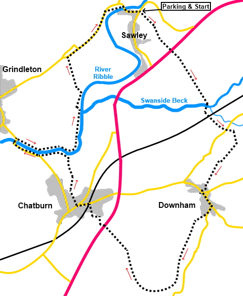
To view route as a dynamic Ordnance Survey map click here. Introduction: This attractive, circular walk starts in Sawley, which I also visited on my Bolton-by-Bowland walk. It then circles through the pretty village of Downham, where one of my Pendle Hill walks starts before reaching Chatburn then returning to Sawley. The walk is generally straightforward but there is steep grassy section on the stretch between Sawley and Downham, for which I feel justified in giving an amber traffic light. If a walk-cum-pub crawl is your thing, you will be well suited because there is the Spread Eagle at Sawley for a pint at the end (I would not normally start with a pint!), the Assheton Arms in Downham (part of a company in Administration at the date of this walk but it will no doubt re-open) and the Brown Cow at Chatburn. As always, check their websites for opening hours. Sawley has remains of a Cistercian abbey originating from the 12th century and a fine bridge over the river Ribble, with at attractive green area alongside. Downham is a very attractive spot with a stream running down the centre. It is an “estate” village, owned by Lord Clitheroe. In addition to the pub, there is a nice café and a free public car park in Downham with toilets, should you want to start this circular walk there. Even if you do not need the services of the toilets, it is worth having a look. They are unusual (I won’t spoil the surprise!). Downham is the start for one of my Pendle Hill walks. Chatburn is a pleasant enough place, formerly a mill town. There is currently a large lime quarry on the outskirts and cement works. I can vouch for the beer at the Brown Cow! There is a bench next to the Brown Cow, should you want a perch for sandwiches. Note there are two occasions when you have to cross the A59. Please note this is a very fast, wide road and you must exercise great caution when crossing. The walk starts from Sawley, an easy place to get to, lying immediately north, off the A59, between Gisburn and Clitheroe. There is plenty of parking on the wide main street. Start: Exit the rear of the Spread Eagle pub car park, immediately crossing a stile into a field and head roughly for the middle of the far boundary. Look out for a large concrete post and keep to the right of it. Go through a kissing gate and over a broad track (SD 779462) and follow the path opposite. Cross a stream and go through a kissing gate. Cross the field and go through another kissing gate to reach the A59 road. Cross with great caution and go through another kissing gate at the other side (SD 781461). Head across the field, heading roughly for the left hand end of Pendle Hill ahead and the left hand corner of the field.
Go through a gate at the corner and head across the next field through the gate which you can see, straight ahead. Cross a stile and follow the left hand boundary. At the end of the field, cross another stile and head to the opposite corner of the field beyond. It was a well worn path.
Cross an awkward stile and descend the obvious path, bearing right as the field levels out and cross the 16th/17th century packhorse bridge, Swanside Bridge, also known as “Fairy Bridge” over Swanside Beck (SD 785454).
Turn left and cross a stone stile. The path soon turns left through a gateway. Follow the left hand boundary. Pass under the railway bridge and up the banking beyond, keeping to the left hand boundary of the next two fields to reach a road. Cross straight over and continue along the lane opposite.
After fifty yards or so, turn right through a kissing gate and follow the path uphill following a yellow arrow. There are some distinct humps here and an outcrop with trees. Pass between the last “bald” hump and the outcrop and then bear right (SD 789449).
You now need to climb the steep hill ahead. Head towards the right hand end, rather than the summit and make your way right, across to the trees. There are good views looking back here to Pen y ghent and Ingleborough. Once over the brow, the onward path leaves the field in the bottom right hand corner by the trees, so when you get to the trees, turn left to follow them down.
Go through a gate (SD 785444) and on joining a lane, turn right in front of Croft Cottage into Downham. At the road close to the church, turn left, passing the pub.
Walk down the road until you reach the picturesque bridge and turn right over it. There is a café here should you need refreshments and just after it, turn right following a public footpath fingerpost up a broad lane, just to the left of the sign pointing to the car park and information centre. There are toilets off the car park.
Follow the obvious footpath, keeping to the right hand boundary of the next two fields. In the next field, the path bears left at about 45° to the boundary. Drop down to a kissing gate and go through this following the yellow footpath arrow and following the left hand boundary of the next field. Ignore a footpath off to the left. The path goes clockwise round Worsaw Hill climbing gently, Keep following the left hand boundary until you crest the hill and down the other side, follow the obvious path straight ahead heading to Chatburn village ahead. Note this short descent can be slippery if wet due to the muddy nature of the path and limestone rocks (SD 775436). The path takes you to the A59 and once more, you need to be very careful crossing it as it is a fast road. Follow the path directly opposite. It wiggles round some gardens before crossing a narrow stony path and over a stile. Keep straight ahead. Cross the field to join a tarmac drive. Climb the stone steps ahead. Go through a tall gate to join a road in front of a long row of terraced houses. Turn left and at the junction, go left again to a ‘T’ junction and turn left, crossing over the railway. At the next ‘T’ junction, go left to the Brown Cow pub, where I can vouch for the quality of the beer! The onward route is to the right of the pub, following a public footpath fingerpost. Go through a gate and follow the right hand field boundary. At the corner, bear slightly right passing under the power lines and follow the path through the trees to the river and turn left to follow the left hand bank (SD 768448).
As you get close to the road bridge, turn left through a kissing gate on to the road. Follow the road over the bridge, then turn right to follow the path along the other side of the river. At SD 769456, the path bears away from the river where continuing along the river is barred by a no entry sign. It goes to a kissing gate at the end of a wall. Go through this and follow yellow arrow. You will reach a banking and there is a “No Right of Way” sign, over a bridge. Turn left to follow the banking and the stream. Go through a kissing gate and turn right to follow a blue bridleway arrow. Keep more or less up the middle of the field to cross a stone stile on to the road. Turn right (SD 768460). You can now just follow the road back to Sawley, or cut off a corner by following a public footpath fingerpost opposite some houses. If you need to buy any hiking equipment/clothing before your trip see the Hiking Store All information on this site is given in good faith and no liability is accepted in respect of any damage, loss or injury which might result from acting on it.
| | |||||||||||||||||

.jpg)
.jpg)
.jpg)
%20Looking%20along%20the%20Ribble%20Valley%20to%20Longridge%20Fell.jpg)
%20Heading%20towards%20Pendle%20Hill.jpg)
%20Fairy%20Bridge.jpg)
%20Railway%20Bridge.jpg)
%20Rocky%20outcrop.jpg)
%20View%20north%20across%20the%20valley.jpg)
%20View%20to%20Pen%20y%20ghent%20and%20Ingleborough.jpg)
%20Another%20view%20of%20Pendle%20Hill.jpg)
%20Main%20street%20in%20Downham.jpg)
%20Downham%20bridge.jpg)
%20Stream%20through%20Downham.jpg)
%20River%20Ribble.jpg)