
|
|
|
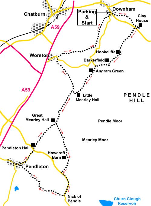
To view route as a dynamic Ordnance Survey map click here. Introduction: This walk is really two walks in one or more accurately two walks with a “there and back” connecting link. If you wanted to, you could therefore treat as two separate short walks, one starting from Downham, where I started and the other from Pendleton, 5 miles and 3.9 miles respectively. Unfortunately, on the day I walked, there was a lot of low cloud and haze so the more spectacular views were not at their best. Downham is also convenient start for walking Pendle Hill. It is an “estate” village, owned by Lord Clitheroe. He also owns Pendle Hill. Successive Lords have ensured the village has remained virtually unchanged for decades without street furniture and TV aerials. The family name is Assheton and they have owned the Downham estate since1558. There is a free public car park in Downham with toilets. Even if you do not need the services of the toilets, it is worth having a look. They are unusual (I won’t spoil the surprise!). Next on our walk is Pendleton. This attractive village has a stream running the full length of its main street where there is a pub, the Swan With Two Necks, which was a coaching inn. The main street was part of the main highway until the A59 by-pass was built. This again is an “estate village” owned by the Aspinall family. As you enter the village, note Fiddle Bridge. This was taken to nearby Standen Hall, during road alterations and returned to the village in 2000 at the initiative of Pendleton Women’s Institute. Its origins are unclear but the main slab is believed to be a very ancient bridge. Finally we touch on Worston, a quiet village with a nice looking pub, the Calf’s Head. I did not try it – I cannot try them all! This is an easy, relatively level walk, with mostly very easy navigation. There are refreshment opportunities at pubs in all the villages. To get to Downham, turn off the A59 just east of Clitheroe. It is signposted although you initially turn off north before passing south over the A59 via a fly-over. Start: Exit the car park (SD 785441) via walkers’ gate close to the toilets. Go straight ahead, crossing the stream by a small bridge.
Turn right along the road, then fork left to walk parallel with Downham Beck (SD 786441). Continue through a walkers’ gate by some cottages and continue to follow the stream, in the direction of the public footpath fingerpost. After 300 yards or so, follow the direction of the waymarker, away from the beck. In the far right hand corner of the field, go through a kissing gate. The path opens into a field. Follow the left hand boundary. At the end of the field, go through another kissing gate and along a fenced footpath. Join a broad farm track which leads (left) to Clay House and turn right along it (SD 794437). At the road turn right for only a few yards and look out on the left for a public footpath fingerpost. Turn left here up a broad track. A sign on the fence reads “Gerna Farm”. Cross a stone stile by the house and follow the path through a kissing gate. In the next field, bear left at about 45°. Go through a kissing gate then bear left across the field to the opposite corner of the field. Go through a kissing gate and turn right following a public footpath fingerpost (SD 789429), passing Hookcliffe Farm, along a short narrow field. At the end of this field, go through a kissing gate to join a broad track. Turn left. Keep a look out for a kissing gate on the left (SD 768428), next to a metal farm gate and through this, follow the grassy track, passing to the left of the house, Barkerfield. Behind Barkerfield is the rounded Worsaw Hill.
At the next farm (Moorside), cross a stream then a stone stile into the farmyard. Go through the farmyard then follow its access track. Immediately after the cattle grid, turn left along a narrower footpath and then right through a kissing gate, following a public footpath fingerpost. Head to the left of the farm ahead (Angram Green). Follow the obvious way-marked path to the left of the farm, crossing a stream via a stone bridge. Continue to the far right hand corner of a large field. Go through a kissing gate and turn immediately right in the direction of the yellow arrow. After a few yards, go through another gate (which was somewhat dilapidated on my visit) and in the field, turn left to follow the left hand boundary (SD 779422). In the far left hand corner of the field, squeeze by a water trough and head for the far left hand corner of the next field. Go through the left of the two gates and follow the stone wall on the right. At Little Mearley Hall, the footpath passes to the right of the large slurry tanks, then between the barns through a gate, to arrive at a wide concreted area. Turn right along the obvious track. When the track curves right, head left along an equally broad track (SD 774418). At this point you have joined the section linking the two halves of this walk referred to in the introduction and along which you will eventually retrace your step on the return.
Follow this broad track, well marked with blue bridleway arrows, for just over a mile, ignoring a path off to the right by Lane Side Farm marked with a yellow arrow. Just past Great Mearley Hall, cross the cattle grid and after 50 yards or so, fork left following a yellow footpath arrow, heading at 90° to the broad track you leave (SD 769407). The path heads uphill. Keep just to the right of some ditches/embankments until you reach a ruined barn (SD 771404). The route is clockwise round the barn and crosses a ladder stile behind it.
After the ladder stile, bear right at about 45° to follow the path which is well trodden and fairly clear. The path leads to Howcroft Barn, in somewhat better repair, which soon becomes visible. At Howcroft Barn, turn left to follow the path above the stream and indicated by the yellow footpath arrow. It is difficult to give precise directions across this rough land. I followed what appeared to be the most likely paths but did not get the last section quite right. However, it matters little because virtually whichever route you pick, you will end up at the road, where you turn left for the Nick of Pendle. The electronic route I have indicated is the route I actually walked (I had not pre-programmed my GPS receiver) but in the absence of the technology, as long as you keep walking roughly south-west and do not significantly climb or descend the slope of the ground, you will hit the road somewhere in the vicinity of Pendle Ski Club. Walking up the road, I noticed a fingerpost at SD 772392, which is where I should have arrived. I was only about 150 yards out! Follow the road to the summit, which is the Nick of Pendle, for the view over Calderdale. However, our onward route is just before the summit, turning right over a stone step-stile following a public footpath fingerpost (SD 771386).
There is a clear path downhill. Follow it for a third of a mile. Keep a look out for a gate on the right with a white notice, indicating Pendleton is through it (SD 766308). Go through the gate and follow the footpath downhill, towards the right of the farm (Wymondhouses). There was a sign on a tree indicating the direction to Pendleton. Go through a white walkers’ gate to the right of the farm and over a stone step-stile. Keep straight ahead with the farmhouse behind you. Look out for a gate on the right and through this, follow the right hand field boundary. At the far side of the field, cross a stile and turn sharply left to follow the left hand field boundary. At the bottom of the field, cross a footbridge and turn left. The path arrives at a small quirky cottage (The Keep). Follow the access track to the road. Continuation of the route is right but a left turn to see Pendleton first is worthwhile. I can vouch for the quality of the beer and sandwiches at the Swan With Two Necks pub! There is also a bench in the village for a picnic.
Returning along the road, past your arrival point, continue along the road, passing All Saints Church, until you get to a ‘T’ junction. Keep straight ahead, following a public bridleway fingerpost.
Follow the long tarmac drive back to Great Mearley Hall and retrace your steps to Little Mearley Hall. This time, after crossing the concrete bridge, go straight on at the junction of tracks. After crossing the cattle grid, fork left to follow the wire fence (SD 774409). At the far left hand corned of the field, go through a crude metal gate and walk straight ahead down the field. A white house soon comes into view. Head for that. At a corner, cross a wooden stile and continue in the same direction. Cross another stile and follow the fence on the left for a few yards and from the corner of the fence, keep straight ahead in the same direction. The path is to the left of the white house. At the end of the field, go over a stile and curve right along the graven drive round the buildings then left to follow the road. At the road, turn left. The road crosses Worston Brook and at the bridge, turn right following a public footpath fingerpost. If you wanted to continue along the road a few hundred yards to Worston village, the Calf’s Head pub is available. Less than two hundred yards from the bridge, look out for a footpath on the right, through a kissing gate, heading towards Pendle Hill (SD 771429).
Follow the right hand boundary fence to the corner of the field then go through another kissing gate to again follow the right hand boundary. At Worsaw Farm, keep straight ahead across a stile – do not fork right. Immediately over the stile, fork left to a gate then follow the wall round to the right. Follow the obvious path to a kissing gate, ignoring a turn off to the right as you get to it. Through the gate, follow the left hand field boundary. At the corner, keep straight ahead, following the clearly trodden path. The combination of well trodden turf, gates and yellow arrows leads you back to Downham on an obvious route. If you need to buy any hiking equipment/clothing before your trip see the Hiking Store All information on this site is given in good faith and no liability is accepted in respect of any damage, loss or injury which might result from acting on it.
| | |||||||||||||||||

.jpg)
.jpg)
.jpg)
%20Bridge%20over%20beck,%20Downham.jpg)
%20View%20over%20Barkerfield.jpg)
%20View%20over%20Ribble%20Valley.jpg)
%20Ruined%20barn.jpg)
%20Ruined%20barn%20rear.jpg)
%20The%20Nick%20Of%20Pendle.jpg)
%20Pendle%20Ski%20Club.jpg)
%20Fiddle%20Bridge.jpg)
%20Pendleton%20Main%20Street.jpg)
%20All%20Saints%20Church%20Pendleton.jpg)
%20Pendle%20Hill.jpg)