
|
|
|
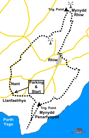
To view route as a dynamic Ordnance Survey map click here. Introduction: This walk to Mynydd Rhiw takes you through pleasant countryside with long distance views to Snowdonia and includes a dramatic stretch of coastline, along a ridge at Mynydd Penarfynydd. There is a slight climb to the summit of Mynydd Rhiw but its summit is only 997ft (304m) so it is not too energetic. There is a trig point on top of a rocky outcrop at the summit and nearby a radio mast. Visible to the east, especially on the tops, there are views of the spectacular Hells Mouth bay, with its long sweep of sandy beach. It acquired the name because sailing ships could easily find themselves trapped there by wind/tide. Along
the ridge SW from Mynydd Rhiw summit is
Clip y Gylfinhir (Curlew's Crag), a prominent pyramid
shaped hill housing a radar station and radio mast. Near to the hamlet of Rhiw is Plas yn Rhiw, now a National Trust property thanks to the generosity of the Keating sisters who restored the dilapidated building, aided by the famous architect Clough Williams-Ellis (of Port Merion fame). They acquired the building in 1939 and eventually donated it to the National Trust along with various areas of land in the area. It is well worth visiting if you have time. The walk starts from a lay-by at LLanfaelrhys. To get there, follow the brown tourist signs from Llanbedrog for Plas yn Rhiw; or initially for Mynytho from Abersoch, turn west along the B4413, then follow signs for Plas yn Rhiw. Pass the National Trust property and at Nant (just two houses on opposite sides of the road), turn left following the road sign for Porth Ysgo. After a quarter of a mile, the parking is to the right in a rough lay-by. There are no facilities on this walk but various pleasant spots for a picnic. Start: From the lay-by (SH 212269), turn right the few yards to the junction and turn right along the road following the Wales Coast Path sign. Stay on the road round the first bend then, after a straight section at the next bend, fork off to the right on a broad track, again following the Wales Coast Path sign (SH 215269). Follow the left boundary of the field as it curves round to the farm (Penarfynydd). Turn right, through the farmyard (confirmed by a public footpath fingerpost) and through the metal gate at the far side. The path beyond here is obvious.
When the path forks, head right for the headland (Mynydd Penarfynydd) from where there are good views in both directions, along the coast. There is an unusual rock structure here on a rock known as ‘Marjorie’s Cottage’. When the rock is seen from the vicinity of Llawenan it supposedly resembles a cottage with a chimney. The stone “sculpture” is maintained by tenants of Penarfynydd to ensure the chimney can be seen, so avoiding bad luck!
From the point, make your way up the hill to the trig point (SH 220266).
From the trig. point, follow the direction of the yellow arrow along the ridge.
At the end of the ridge, follow the footpath along a walled lane. Before getting to the houses, turn right through a gate (or cross the stile alongside). The route along the coast is obvious and well marked. Just avoid any tracks/paths which descend to the right.
Eventually, you reach a small stone cottage where the path drops down to the corner of the boundary wall and goes left along a broader path (SH231274). There are good views of distant mountains here.
Beyond the cottage, keep on the main track to the left of the wall (don’t go right at the corner).
At a white painted cottage (SH232276), turn left up a broad track and follow the track as it climbs to the hamlet of Rhiw. At the road, turn right. After a few yards, turn left to follow a public footpath fingerpost (SH 228278). Bear slightly right to cross a stile and follow the right hand field boundary. Immediately after walking under the power lines, turn right, then left on a broad stony track to the road. At the road, turn right. Follow the road as it curves left and turn right on the broad track to the left of the bungalow (SH 226281). When the track forks, by a stone cottage and some mobile homes, fork right. When the track forks again, just before the power lines, go left and left again at the next fork. At a cross road of tracks, where there is a post with multiple yellow arrows, keep straight ahead heading for the radio mast but work your way left to the wall. You are looking for a stile which is easy to miss. Cross the stile. Take the little path heading slightly left. It joins another path after a few yards. Turn right (SH 230291). As you get closer to the mast, the path curves left to the trig point, crossing two broad tracks on the way, the second being the access track to the radio mast. There is a great 360° view from the trig. point, set atop a rocky promontory on Mynydd Rhiw (SH 229294).
Return to the access track and turn right and turn right, heading initially for the curious conical hill of Clip y Gylfinhir. Another radio mast and radar scanner are to its left.
You reach a section where stones have been used to “pave” the track, follow for a few yards then fork right (SH227288). At a cross roads of tracks keep straight ahead. On meeting the next track, turn left. Look out for a less used track on the right which will take you to a stone step stile (SH223286). Cross this then bear right.
The path now crosses rough pasture with dwarf gorse which is quite a nuisance. It is quite difficult to suggest the right route here. The area is Access land so you are free to pick your own route. I followed the wall initially, along an apparent path before heading left at the corner and making my way down the hill. Soon visible in the wall at the bottom is a gate, about half way along the wall. The gate is marked with a yellow arrow indicating your onward course down what looks like an old walled lane to the road. Turn left along the road and immediately right at the junction. Follow the road to the cross roads and go straight across following the sign for Porth Ysgo (the way you approached by car). Arrive at the parking after a quarter of a mile.If you need to buy any hiking equipment/clothing before your trip see the Hiking Store All information on this site is given in good faith and no liability is accepted in respect of any damage, loss or injury which might result from acting on it.
| | ||||||||||||||||

.jpg)
.jpg)
.jpg)
%20View%20west%20over%20Porth%20Ysgo.jpg)
%20View%20from%20Trwyn%20Talfarach%20to%20Hells%20Mouth.jpg)
%20Marjories%20Cottage.jpg)
%20Path%20to%20trig%20point.jpg)
%20Trig%20point%20at%20Mynydd%20Penarfynydd.jpg)
%20Looking%20back%20along%20the%20ridge%20of%20Mynydd%20Penarfynydd.jpg)
%20Cottage%20at%20Mynydd%20y%20Graig.jpg)
%20View%20over%20Hells%20Mouth.jpg)
%20Summit%20of%20Mynydd%20Rhiw.jpg)
%20View%20along%20the%20ridge%20at%20Mynydd%20Rhiw.jpg)
%20Looking%20SW%20to%20Bardsey%20Sound.jpg)