
|
|
|
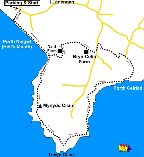
To view route as a dynamic Ordnance Survey map click here. Introduction:
Mynydd
Cilan is a predominantly grassy hill on the southern coast of the Llŷn
Peninsula, rising to 384ft (117m). There is a trig. point at the summit and
there are fine views from here over the vast sandy bay of Porth Neigwl
(Hell’s Mouth), from where the walk starts, as well as across the
peninsula to Abersoch. Porth Neigwl (Hell’s
Mouth), gets its name because it faces south-west and receives the full
force of Atlantic gales. This has meant many a sailing ship being trapped
there and coming to grief. The area at the rear of
the bay was used as a bombing range and practice area for airmen until 1945
and there are the remains of some buildings still. There is a good chance
of seeing a variety of bird life including chough, Cormorant
Shag and Kittiwake. Dolphins may be seen, especially in summer. The walk is
straightforward with little to worry about in the way of steep inclines. The walk starts at the
free car park at Porth Neigwl (Hell’s Mouth). To get there, take the road
signposted for Porth Neigwl, from the centre of Abersoch. Stay on this road
through the village of Llanengan, in the centre of which is another sign for
Porth Neigwl. Follow the road as it bends sharp right at a box junction. The
parking is on the left after about a quarter of a mile. There are no facilities on this walk but plenty of
nice picnic spots. Start: From the car park, take the path by the information board to the coast and turn left on the Wales Coast Path.
The combination of well worn turf, signs and stiles make the path easy to follow. Continue out to the headland where it starts to climb. At the top, turn right to follow a yellow arrow out to the headland.
Just past the trig point (SH 289242), the path divides. Stay on the higher level path.
In the area of the point at Trwys Cilan, there are some dramatic rocky cliffs (SH 295232).
At SH 302238, you cross a stream via a bridge; quite a scenic spot.
The next section of this walk is easy to follow and needs no directions. Just continue to follow the Coast Path.
Eventually you reach a long beach (Porth Ceiriad) and the path, still well marked, does some strange dog-legs round a field.
When you get to the rear of the beach, about three quarters of the way along it, you should spot a track heading up to the left and another off up to the right. Take the left track (SH 313249). Do not confuse with the private track going to the campsite. There is a three way fingerpost marking the turn you want. As you ascend the track, you pass a National Trust sign showing you have been on their land - Porth Ceiriad. Go through a walkers’ gate next to the campsite (not into the campsite itself). You reach a rough track which becomes a tarmac road. Follow this until it turns right by a white painted cottage. On the bend (SH 311255), bear off left (effectively straight on) through a kissing gate, following a public footpath fingerpost. Just past the house, turn left (SH 310256) to follow the left hand field boundary to a stile in the corner (SH 310255). Cross it then turn immediately right to follow the right hand field boundary. Ignore the stile immediately on the left. Over the next two stiles, keep straight ahead at both. Go through a kissing gate and continue along the path, initially with hedges either side. Pass the farmhouse joining the track to the farm and turn left. Follow the track to the road and turn left (SH 304258). Walk along the road for about 200 yards. Turn right at a metal farm gate on the right and walk along the fenced track (SH 304256). Note there is no sign here but there is only one such track and it is about 100 yards before you get to a road junction on the left. The onward route at the farmhouse may not be clear at first but it is to the right of the farmhouse where there is a small stile. Cross it and turn left to follow the left hand field boundary to another stile. Cross it and turn left along the farm track. At Bryn Celyn Farm (SH 302257), the track passes to the right of the farm buildings. Along this track are fine views to Abersoch and mountains beyond. Stay on the track and over a cattle grid, the entrance to Nant Farm Just before Nant Farm, turn left up a steep banking opposite a stone cottage (SH 294258). There is no onward public access at Nant Farm itself unfortunately, which causes this circuitous route. At the top of the banking, cross a stile and bear right to follow the white arrow. The path drops down to cross a stream via a three plank bridge. Continue up the other side following the arrows. Cross another stile and follow the right hand field boundary to another stile, from where the route to the Coast Path is obvious. Join a broad track and turn right. This leads to a kissing gate. Go through this and head for the diagonally opposite corner of the field where you rejoin the Coast Path. Turn right to retrace your steps to the parking. If you need to buy any hiking equipment/clothing before your trip see the Hiking Store All information on this site is given in good faith and no liability is accepted in respect of any damage, loss or injury which might result from acting on it.
| | ||||||||||||||||

.jpg)
.jpg)
.jpg)
%20Hells%20Mouth.jpg)
%20Looking%20towards%20Mynydd%20Cilan.jpg)
%20Looking%20back%20to%20Hells%20Mouth.jpg)
%20Trig%20point%20at%20Mynydd%20Cilan.jpg)
%20View%20to%20Porth%20Ceiriad.jpg)
%20Cliffs%20at%20Trwyn%20Cilan.jpg)
%20Looking%20back%20from%20Trwyn%20Cilan.jpg)
%20View%20round%20the%20bay%20of%20Porth%20Ceirian.jpg)
%20Stream%20at%20SH%20302238.jpg)
%20Looking%20back%20towards%20the%20point.jpg)
%20View%20towards%20Abersoch.jpg)
%20Beach%20at%20Porth%20Ceiriad.jpg)