|
Wharram
Percy to Thixendale
|
Starting
point and OS Grid reference:

Free
car park at the Wharram Percy medieval village site
(SE 867645)
|
Ordnance
Survey Map
OS
Explorer 300 – Howardian Hills and Malton.
Buy this map from
List
of OS Maps
Commission from map sales is
used to fund the website, so keeping it free to use.
| |
Distance: 7.9 miles
| |
Traffic light rating:

(For explanation see My
Walks page)
| |


For advice on .gpx files see
My
Walks page
|

Click
the PDF logo above to give a printable version of this walk without the
photos.
|
To
view route as a dynamic Ordnance Survey map click here.
Introduction:
This
Yorkshire Wolds walk from Wharram Percy to Thixendale provides an
opportunity to examine the remains of the deserted Wharram Percy medieval
village and its ruined church, the prettily sited village of Thixendale and
enjoy the beauty of some almost artistically perfect valleys, sculpted by
glaciers.
There are supposedly some 3,000 or more
deserted medieval village sites in the country but Wharram Percy, abandoned
in around 1500 AD is one of the most studied. The site of many of the
buildings can be seen – this is especially noticeable from aerial photos.
English Heritage has provided numerous boards which give much information
and the outlines of some buildings have been depicted by edgings and gravel.
%20Aerial%20shot%20of%20Wharram%20Percy.jpg)
Between 1950 and 1990, led by Maurice
Beresford and John Hurst, historians, archaeologists, and botanists,
literally dug extensively into the village’s past. It seems after a
natural decline, the last remaining villagers were removed by the lord of
the manor to make way for sheep!
%20Archeological%20dig.jpg)
Much of the church remains.
The route follows the Yorkshire Wolds Way,
Centenary Way and Chalkland Way signs and the crossing and linking of these
names can be confusing at times but the paths are easy to follow on the
ground. In the process, there are views of the spectacular valleys -
primarily Deep Dale, Water Dale and Thixen Dale.
The route passes through the high wold
village of Thixendale. It is a popular spot for walkers being on the 79 mile
long Wolds Way which runs from Hessle to Filey Brig. There is a small shop
and a pub, although judging from its sign, it does not open at lunch times.
Several information panels, at the village hall, tell you about the village
and the area.
The walk is straightforward and mostly level.
It starts from the free car park which serves the Wharram Percy medieval
village site. To get there, turn SW off the B1248 just south of the village
of Wharram-le-Street. The car park is just over half a mile from the turn,
on the right.
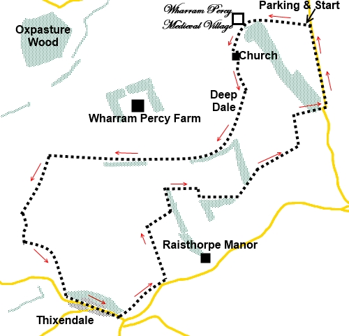
Start:
Take the obvious footpath at the rear of the car park which descends gently.
At a kissing gate, a fingerpost points to the Wolds Way and you continue in
this direction to the right of a hump in the ground.
You soon come to the site of the medieval
village (SE 858643), marked by an English Heritage information board. As you
progress along the track towards the cottages, you need to veer off to the
right, up the bank, to get a closer view of the village remains. There are a
number of panels with information about the settlement.
%20Wharram%20Percy%20sites.jpg)
%20Old%20Cottages%20at%20Wharram%20Percy.jpg)
%20Wharram%20Percy%20Church.jpg)
When you have had your medieval fill, return
to the main track and go through the gate into the courtyard area. Walk
round the cottages and have a look at the ruined church. The route continues
through the graveyard, all marked with yellow arrows.
%20Inside%20Wharram%20Percy%20Church.jpg)
%20Inside%20Wharram%20Percy%20Church.jpg)
At the old fishpond, you have the option as
to which way round it you go. An anti-clockwise circuit takes you over a
footbridge, with an attractive view. Clockwise takes you past another
information board. Either way, you need to follow the oddly angled
fingerpost for “Yorkshire Wolds Way and Thixendale 3½ miles,” up the
bank (SE 859642).
%20View%20Across%20Fish%20Pond.jpg)
At the top of the bank, the path bears right
following the direction of another fingerpost for the “Wolds Way”. You
follow the valley of Deep Dale and as it curves round, although still on the
Wolds Way, you also join the Centenary Way for about ½ mile, in effect
turning right as you join it (SE 858630).
%20Deepdale.jpg)
Continue to follow the top of the valley.
After the ½ mile, at a three-way fingerpost, the Centenary Way goes off to
the left but you keep straight ahead.
After a further ¾ mile, you meet the drive
to Wharram Percy Farm (SE 836629). Turn left, continuing to follow the Wolds
Way/Centenary Way fingerpost. It is perhaps worth mentioning that this
perhaps unexpected re-meeting with the Centenary Way is because it has
looped round via Thixendale to the south. You now follow both to Thixendale
village.
%20Wolds%20Way%20marker.jpg)
As the farm track bends right, keep straight
ahead into a field and follow its left hand boundary. At the end of the
field, the route drops down a grassy track to Vessey Pasture Dale. In the
valley bottom can be seen the remains of ancient earthworks.
Climb the obvious path at the far side of the
valley up Vessey Hill and through a kissing gate, turn right.
%20Descending%20to%20Vessey%20Pasture%20dale.jpg)
At the top of the hill, follow the right hand
boundary of the field. At the corner, turn left, following the yellow arrow
and finger post for “Wolds Way” (SE 833619). Turn right at the next
“Wolds way” fingerpost, joining a broad track between the fields. Turn
left on this, heading towards the right hand side of a wood.
The track forks, the left leg heading for a
barn but ignore this and keep straight ahead. The track descends to the
attractive village of Thixendale passing the ends of Water Dale (with the
road through it) and Thixen Dale, almost parallel.
%20Thixen%20Dale%20&%20Water%20Dale.jpg)
Meet the road through Thixendale village at
Cottage farm. Turn left. There is an interesting village hall with
information panels about the village and the area.
%20Approaching%20Thixendale%20Village.jpg)
%20Pump%20in%20Thixendale.jpg)
%20St%20Mary's%20Church%20Thixendale.jpg)
%20Thixendale%20Village%20Hall.jpg)
As you near the end of the village turn left
by the Cross Keys pub following the “Centenary Way” fingerpost (SE
845610).
The path passes the cricket/football field to
the right of the pavilion, along the valley floor. Keep to the left of the
valley floor ascending the side slightly left, to meet a stile and
fingerpost.
As you get to the end of the field, join a
broad track briefly. You can see the fingerpost at the base of the hill (SE
850615). Follow the Centenary Way path up the hill to the left of the trees,
to walk along the top of what is Court Dale.
%20Honey%20Dale.jpg)
As you get to the end of Court Dale, where it
turns left to become Honey Dale, turn right through a walkers' gate and
right at a broad track (SE 848621). Continue along this track until at SE
851623, turn left at a broad track following the fingerpost for “Centenary
Way” and “Chalkland Way”
Keep straight ahead on this track, ignoring
one which forks off left along the side of a large field. The next
fingerpost is visible ahead.
At this fingerpost, turn right following the
public bridleway sign (SE 850625).
Follow the path through the trees and follow
the left hand boundary of the field you come to. At the end of the field, go
through the gap in the hedge and turn right, to follow the right hand
boundary of the next field.
Turn left at the corner, following the public
bridleway arrow, along the edge of the trees.
At the next corner of the field, join a broad
bridleway, turn left.
At the end of this field, go through the gap
in the hedge and turn left to follow the left hand field boundary. There are
some faded arrows on a post and it is not easy to decide which side of the
hedge to walk along but you definitely want the hedge on your left as is
clear from the next fingerpost you reach.
You cross the top of a second, narrower field
and at the end of it, turn right (SE 865634). Follow the path to the road and turn left. There are
good views along the road here. The road leads back to the car park.
%20Views%20From%20Road.jpg)
If you need to buy any
hiking equipment/clothing before your trip see the Hiking
Store
All information on this
site is given in good faith and no liability is accepted in respect of any
damage, loss or injury which might result from acting on it.
|


.jpg)
.jpg)
.jpg)