
|
|
|
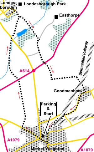
To view route as a dynamic Ordnance Survey map click here. Introduction: This is a straightforward walk along easy to follow paths/lanes etc. It starts in Market Weighton, a quiet, country and as the name suggests, market town, having been granted its charter in 1251. Its main claim to fame seems to be that it is the birth place of Britain’s tallest recorded man, one William Bradley, who, by the age of twenty, was 7 ft 9 in tall and weighed 27 stone. Born in 1787, he died on the 30th May 1820. He is celebrated each May with the Giant Bradley Day festival. Londesborough is a pretty, tranquil village with a lovely, Norman All Saints church. There are benches here should you want a seat for a picnic. Londesborough is the home of Londesborough Park, with parkland laid out in the 17th century with 18th century alterations. It has lakes and cascades. It is registered under the Historic Buildings and Ancient Monuments Act 1953. Londesborough Hall was demolished in 1818. The present hall (Londesborough Park) dates from 1839 but is a private house, so it is the parkland to which this walk has access. One unusual feature in the park is a series of brick built deer shelters, perhaps marking the previous importance of hunting/shooting! The walk passes through the village of Goodmanham, where the Goodmanham Arms provides a pleasant refreshment stop. Alternatively, there is a cafe Fiddle Drill based at Manor Farm but to find this, you would need to turn left on arriving in the village, before continuing the route. The walk starts in Market Weighton which is easy to find along the A1079 in East Yorkshire. Head for the town centre where there is free parking, accessed via Londesborough Road, off Market Place. The road is signed for Londesborough, Goodmanham, Driffield and the Community Centre. Start: Exit the car park (SE 877419) via the arch and turn right along York Road. Pass a business park on the left and after the end of the houses on the right, turn off the road to follow a fingerpost for “Yorkshire Wolds Way” and “Londesborough 2 miles” (SE 872421) Follow the obvious path across the first field, following the line of the power poles. After crossing a little bridge, follow the right hand boundary of the following fields, until you reach the road (A614) (SE 871435). Cross the road (take care it is a fast and busy road) and follow the drive for Towthorpe Grange and a fingerpost for “Wolds Way” and “Londesborough 1½ miles”. Follow the drive past the Grange, to the right of an open barn and through a kissing gate. The obvious path goes through a gap in the trees, straight ahead. Once through the trees, the path curves gently right to a kissing gate. Once through this, follow the right hand field boundaries until you get to a road. Turn left along the road, for no more than a hundred yards and look out for a “Yorkshire Wolds Way” finger post on the right, where you leave the road, through the imposing gateposts formerly of Londesborough Hall (SE 869448). The fingerpost also declares “Londesborough½ mile”.
Pass the former lodge house and stay on the obvious track through the gate ahead.
When the track splits at a three way fingerpost, continue straight ahead, following the finger for “Londesborough”. Note the brick structures of the old deer shelters.
Go through two kissing gate and at the junction with the road, turn left along it to visit the village and church (SE 871454).
Return to the two kissing gates. It is best to go through the left one, then keep straight ahead, ignoring the path which goes off immediately to the left. On meeting a broad track, turn left. After going through another kissing gate, the track forks. Go left. As you drop down the hill, if you look back, you can see the current Londesborough Park. Continue downhill to cross the cascade via the footbridge, passing an acorn Wolds Way marker. The route beyond is obvious and bends slightly left at first before rounding the end of a wood.
As you get to the end of the trees, look out for a fingerpost ahead, where you turn right to follow the sign for “Yorkshire Wolds Way”, along a broad farm access track (SE 877447). As the farm track bends sharply right, fork off to the left at a three way fingerpost (in effect, straight on), again following the sign for “Yorkshire Wolds Way”. At the road (A614), cross straight over Towthorpe Picnic Site and follow the fingerpost for “Wolds Way” and “Goodmanham 1 mile”.
Follow the right hand boundary of the field, turning left at the corner to follow the fingerpost. Just after passing a fingerpost pointing to a footpath on the left, the track divides. To the right, a shorter route will take you more directly back but this misses out much of the village of Goodmanham and its church, so I recommend keeping straight on. The difference in distance is minimal. Follow the track under the arch of the disused railway and into Goodmanham, passing All Hallows Church. At the ‘T’ junction, turn right (SE 890432).
Follow the road round the corner, passing the Goodmanham Arms and stay on the road until you reach the unmistakable Mill House on the left. Immediately after this, turn left at the road junction and immediately right to follow a public footpath fingerpost by the stream (SE 884425). Follow the path as it turns right under the railway arch, then turn immediately left to walk parallel with the embankment. At the end of the field, in the left corner, turn left on to the old railway track and right to walk along it. Follow the path along the left hand side of the open park area. Just before the children’s playground, turn left along the tarmac footpath. At the road (Finkle Street), turn right for Market Weighton town centre. At the end of Finkle Street, turn right to return to the car park. If you need to buy any hiking equipment/clothing before your trip see the Hiking Store All information on this site is given in good faith and no liability is accepted in respect of any damage, loss or injury which might result from acting on it.
| | |||||||||||||||||

.jpg)
.jpg)
.jpg)
%20Old%20gateway%20to%20Londesborough%20Park.jpg)
%20Former%20lodge%20house.jpg)
%20Deer%20shelters.jpg)
%20Looking%20over%20Londesborough%20Parkland.jpg)
%20All%20Saints%20church,%20Londesborough.jpg)
%20Cottages%20at%20Londesborough%20village.jpg)
%20Current%20hall%20at%20Londesborough%20Park.jpg)
%20Lake%20at%20Londesborough%20Park.jpg)
%20Wolds%20Way%20marker.jpg)
%20View%20towards%20Park%20Farm.jpg)
%20Weather%20approaching.jpg)
%20Big%20skies.jpg)
%20Approaching%20the%20old%20railway%20bridge%20at%20Goodmanham.jpg)
%20All%20Hallows%20Church,%20Goodmanham.jpg)