|
Fridaythorpe
Walk
|
Starting
point and OS Grid reference:

Fridaythorpe
village – on street parking by the village pond.
|
Ordnance
Survey Map
OS Explorer Map 294 - Market
Weighton & Yorkshire Wolds Central.
Buy this map from
List
of OS Maps
Commission from map sales is
used to fund the website, so keeping it free to use.
| |
Distance: 8.8 miles
| |
Traffic light rating:

(For explanation see My
Walks page)
| |


For advice on .gpx files see
My
Walks page
|

Click
the PDF logo above to give a printable version of this walk without the
photos.
|
To
view route as a dynamic Ordnance Survey map click here.
Introduction:
This is a circular walk in the
Yorkshire Wolds exploring some of the unusual dry valleys sculpted by
glaciers. This is useful country in which to walk after heavy rain because
it overlies chalk and so drains quickly. The never ending rain in the latter
part of 2012 caused me to look for somewhere which would not be ankle deep
in mud for a change and the Wolds delivered. The walk does not go near any
rivers/streams, which are in short supply hereabouts. Indeed, the shortage
of water caused a “battle” in 1826 between Fridaythorpe and the
neighbouring village of Fimber. An information board by the village pond
tells you all about this and other historical facts.
The walk begins in Fridaythorpe a quiet
unassuming sort of place with at attractive village pond and tiny 12th
Century Norman church of St Mary’s. Fridaythorpe is the highest village in
the Yorkshire Wolds at 561 ft (171m). Part way round the walk is an option
to visit the village of Huggate. The walk follows The Wolds Way in some
sections. Fridaythorpe lies on the A166 between Driffield and York.
There are plenty of gentle ups and downs as
we traverse the dry valleys (or dales) but they are all a gradual process
and so I have graded the walk with all green traffic lights.
Refreshments are available at The Wolds Inn
at Huggate (check opening times).
%20Village%20Pond%20at%20Fridaythorpe.jpg)
%20St%20Marys%20Church%20Fridaythorpe.jpg)
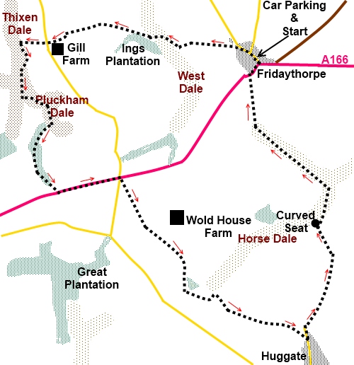
Start:
With your back to the village pond, turn left and walk along the main
street. At the mill complex, turn left following the fingerpost “Wolds
Way” and “Thixendale 3¾ miles”.
After crossing the access road to the mill
and weighbridge, the track continues straight ahead following the left hand
boundary of the large field, at the end of which, turn right through a metal
kissing gate signed for Brubber Dale (SE 883570).
Follow the path as it descends to bottom of
the dale then turn right to the gate and fingerpost visible in the corner
and continue to follow the Wolds Way sign.
There is a long gentle climb out of the dale
to a kissing gate. Go straight ahead initially then follow the track as it
curves round to the left. It soon turns sharp left to a farm but go straight
ahead here passing under the powerlines.
Cross a road (SE 848593) and continue
straight ahead following the Wolds Way sign.
The track goes through a gate then curves
left briefly along the top of Thixen Dale before descending to the valley
floor. You will see a spiral art installation “Time & Flow” created
by Chris Drury which you walk past. Now
leaving the Wolds Way, follow the dale round to the left passing the artwork
and following the yellow arrows (ignore the blue arrows at this point).
%20Thixendale%20and%20Time%20and%20Flow%20artwork.jpg)
After a short stint along the dale floor, go
over a stile and left following the yellow arrows and continuing along the
dale. At a ‘T’ junction of dales, go left into Pluckham Dale and follow
the path as it swings right to the trees, following their edge initially
then, after going through the trees, the track emerges at a large field.
Turn right to the main road (A166) and turn left (SE 850575).
Walk along the road (there are reasonable
verges) for about half a mile then at the cross roads, turn right following
the direction of the road sign for Huggate. No more than 15/20 yards from
the junction, turn left off the road on to the footpath across the field
indicated by a fingerpost.
The path follows the right hand side of the
hedge then crosses a tarmac drive to Wold House Farm. Keep straight ahead.
The path passes between a fence and a hedge
then after going through a five bar gate, descends into Horse Dale. At the
bottom, turn left, then go immediately right through a walkers gate and
climb the dale at the other side up the obvious track.
At the top of the dale, turn left, and walk
along for a short distance. This is a particularly attractive dale with
perfect curves but do not get carried away and miss the gate on the right
hand side with a yellow arrow (SE 870562).
%20Horsedale.jpg)
You join a metalled track and turn left along
it returning to the Wolds Way which essentially we now follow all the way
back to Fridaythorpe. As you get to a farm (Glebe Farm), where there are a
pair of brick built cottages, bear right (indicated by a yellow arrow and
acorn sign before the cottages). The path goes round the farm to
rejoin the tarmac track where you turn right (SE 878559).
Look out for a kissing gate on the right hand
side with a yellow arrow and fingerpost. This footpath leads to the village
of Huggate – you will see the church spire. It is up to you whether you
want to take this ¼ mile diversion. There is not a great deal to see apart
from the rather nice 12th Century St Mary’s church (another one!) with an
impressive stained glass window. If you walk through the village to the
crossroads and turn left, there is the Wolds Inn. If you do, note that as
the footpath exits into the road, almost opposite the church (you need to go
right then left to see it), the continuation of our main route is to the
left down the road.
%20St%20Marys%20Church%20Huggate.jpg)
%20St%20Marys%20stained%20glass.jpg)
If you ignore Huggate, remain on the tarmac
drive from Glebe Farm and at the road, turn left (SE 881557).
Continue along the road passing a fingerpost
indicating the Wolds Way and Fridaythorpe 2½ miles. Also pass a sign for
Northfield Farm.
%20Tree%20lined%20approach%20to%20Northfield%20farm.jpg)
As the road bends right, take the footpath
off to the left marked with a fingerpost for the Wolds Way and Public
Bridleway (SE 885567). The path follows the right hand side of the hedge.
You pass an unusual curved seat, created by
artist and furniture maker Angus Ross, at SE 883 571, overlooking Horse Dale
and follow the track down into the dale. Head right.
%20Curved%20seat%20overlooking%20horse%20dale.jpg)
You come to a five bar gate on the left which
continues the Wolds Way (there is a fingerpost) along the valley floor for
about half a mile (at a fork in the valley, keep right) before the path
starts to climb. Go through a walkers gate and continue straight ahead.
At the main road in Fridaythorpe, turn right
then left at the bend and pub Farmers Arms to return to your car.
If you need to buy any
hiking equipment/clothing before your trip see the Hiking
Store
All information on this
site is given in good faith and no liability is accepted in respect of any
damage, loss or injury which might result from acting on it.
|


.jpg)
.jpg)
.jpg)