
|
|
|
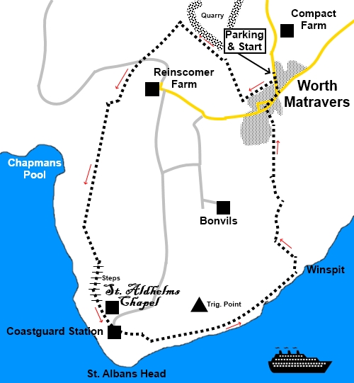
To view route as a dynamic Ordnance Survey map click here. Introduction: St. Albans Head is the most southerly outpost of the Purbeck Peninsula. It seems to have a dual name on the basis that St. Alban’s is a corruption of St. Aldhlems. From it are spectacular views of the Dorset coastline. The walk should have a green rating throughout but the sheer number and steepness of steps encountered about half way into the walk prompt the amber. There are steep cliffs so keep away from edges. I kept the walk quite short on account of the heat that day but you could combine it with part of my Dancing Ledge and Anvil Point walk if you wanted a longer excursion. There are a number of fascinating aspects to this walk. I give a brief synopsis but there is much more information on the topics to find on the walk. The first unexpected event was coming across a stone plaque set in a wall with the inscription “Between Turf and Sky”. This is one of six such stones on the South West Coast Path set into dry stone walls by volunteers from the Dry Stone Walling Association. The verses were written by local poet Paul Hyland. Along this section of the walk are views down to Chapman’s Pool, which you can go down to if you wish but it is reputedly hard work (I did not venture). The cove is a grey bowl of Kimmeridge Clay Shale, with a rocky beach and was a haven for smugglers in the 19th century. There is a good chance of finding fossils. The cove at one time housed a lifeboat but this service was removed as not viable in 1880. The building is now one of the fishing huts. If you do venture down, stay clear of the unstable cliffs. Shortly afterwards, you come to the impressive and beautiful War Memorial, complete with large stone picnic table from which you can admire the view. This was built by the Dorset Branch of the Royal Marines, to pay tribute to their members who have been killed since 1945. At St. Alban’s Head, is St. Aldhelm’s Chapel. This is a Scheduled Ancient Monument but is also an open church still used. It is a most unusual shape, being square and with its corners in the directions of the cardinal compass points. It has impressive vaulted ceilings. It dates from the 12th or 13th centuries. A local legend says that it was built by a distraught father to commemorate the drowning at sea of his newly married daughter and husband while he looked on. Old graffiti has been carved into its central pillar. A leaflet in the church gives much more information. By the chapel is a coastguard station, now manned by volunteers of the National Coastwatch Institution (NCI). Following a Government decision to close coastguard stations and rely on electronics, in the early 1990s, a fishing boat promptly sank in 1994 with two lives being lost. This happened near a recently closed lookout station. So, the NCI was born. More prosaically, you can thank the top secret activity that went on in this area during World War II for a commonplace kitchen item. The resonant cavity magnetron, developed by Birmingham University, was deployed here in radar and a version of it powers your domestic microwave. Evidently over 2000 people were employed in these parts on radar research but all traces of their activities have virtually disappeared. A sculpture has been erected to commemorate their work. As you walk back from the coast to Worth Matravers, if you look up to the hills on either side, you can see the remains of Strip Lychets, which are earth terraces and part of medieval field systems. If, like me, you appreciate a really good pub, you have a treat in store on your return to Worth Matravers where you will find the Square and Compass which dates back to 1752. Its beer garden has a number of tables simply made of huge slabs of stone, with seats to match. It also houses a fossil museum. The beer was fabulous! The walk starts at Worth Matravers, a pretty and upmarket looking village with a duck pond. To get there, take the B3069 from Swanage or Corfe Castle and turn off where signposted. There are two roads into the village but if you take the one closer to Corfe Castle, you will arrive in the village at the car park. Start: Exit the car park (SY974777) and turn right along the road. Turn off the road, opposite the Square and Compass pub following a fingerpost for “Hill Bottom and Chapman’s Pool 1¼ miles”. A combination of yellow arrows, gates and a well trodden path make this section of the walk straightforward. Join another footpath, where to your left you will see a three way fingerpost (SY 971775). Turn right for “Chapman’s Pool”. Continue in the same line along the left hand boundaries of the following fields, heading towards the quarry. As you get close to the edge of the quarry, cross over a stile by a three way fingerpost following “Chapman’s Pool” again (SY 970778). Continue to a stile and cross it to join a bridleway (SY 966782) and turn left to follow the fingerpost for “Chapman’s Pool 1¼ miles”. (Clearly little progress has been made since the first fingerpost!). The path forks (SY 963779) but keep straight on following the left fork then go immediately left again, to drop down to a broad tarmac lane, where you turn right for “Chapman’s Pool 1 mile”. At SY 962777, turn left at a three way fingerpost, following the bridleway sign for “St. Aldhelms 1½ miles”. After going through a walkers’ gate, fork left, for the coast path. The route is marked with a large stone direction sign. When you get to the coast path, turn left. You now get good views of Chapman’s Pool.
At SY 959770, pass the plaque in the wall “Between Turf and Sky”. Shortly afterwards, you come to the impressive War Memorial (SY 959768),
At SY 959761, you begin a very long, steep descent of steps into a valley. The bad news is that there is an equally steep ascent at the other side. I defy you not to rest on the stone bench at the top!
The walk continues to round St. Alban’s Head where there is a volunteer manned coastguard station and the old chapel of St. Aldhelm.
At SY 976760 you reach disused Winspit Quarry. Once past this, the path drops down some steps to join a broader track. Turn left here. A stone sign at the foot of the steps confirms this is the way back to Worth Matravers.
As you get within clear sight of the village, branch right off the main track (SY 974768). The rough path turns into a tarmac path and opens into the street by a row of cottages. Turn right. At the road junction, turn right again, passing the village green and its duck pond. At the next road junction, turn right.
Turn left at the next road junction, following the road sign for Kingston and Corfe Castle, to return to the car park. If you need to buy any hiking equipment/clothing before your trip see the Hiking Store All information on this site is given in good faith and no liability is accepted in respect of any damage, loss or injury which might result from acting on it.
| | |||||||||||||||||

.jpg)
.jpg)
.jpg)
%20Chapman's%20Pool.jpg)
War%20Memorial.jpg)
%20View%20from%20the%20war%20memorial.jpg)
%20The%20Steps.jpg)
%20Steep%20cliffs%20near%20Chapman's%20Pool.jpg)
%20St%20Aldhelms%20Chapel.jpg)
%20Vaulted%20ceiling%20in%20St%20Aldhelm's%20Chapel.jpg)
%20Graffiti%20in%20St.%20Aldhelm's%20Chapel.jpg)
%20Inside%20St%20Aldhelm's%20Chapel.jpg)
%20Cliffs%20and%20weird%20rock%20at%20St%20Albans%20Head.jpg)
%20Memorial%20to%20wartime%20radar%20work.jpg)
%20View%20along%20the%20coast%20path.jpg)
%20Winspit%20Quarry.jpg)
%20Strip%20Lychets.jpg)
%20Village%20pond%20at%20Worth%20Matravers.jpg)
%20Square%20and%20Compass,%20Worth%20Matravers.jpg)