
|
|
|
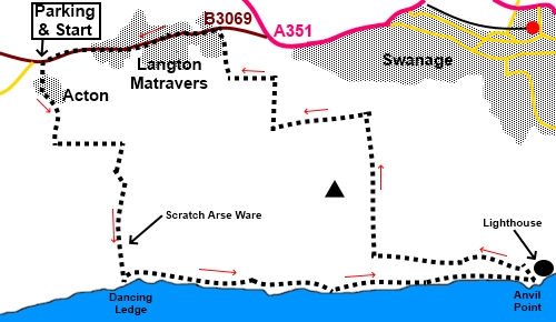
To view route as a dynamic Ordnance Survey map click here. Introduction: It is difficult to resist a section of coast named Dancing Ledge and even more curious to cross an area known as Scratch Arse Ware (according to the National Trust), “ware” evidently being an old, local word for rough grazing land. Later, the route turns away from the coast at the Anvil Point lighthouse. The going is pretty easy on this walk and you will be rewarded with good views along the coast, of the Purbeck Hills and over Swanage. There was also a plethora of wild flowers when I did the walk. Dancing Ledge, by an old Portland Stone cliff quarry, is a horizontal bed of rock which may get its name on account of the “dancing effect” waves create on its surface, when the tide is right, although there are other equally implausible explanations. It provided a natural quayside for loading quarried Purbeck Stone. The quarrying ended in Victorian times. It is currently a popular venue for climbers. The Anvil Point lighthouse was completed in 1881. It became automatic in 1991. Its light has a range of about 10 miles. It was built to guide vessels along the Channel Coast. The former lighthouse keeper’s cottages are now holiday lets. The walk starts from a rough car park just off the B3069, just over a mile from where it joins the A351 just outside Swanage. Turn south off the B3069, following the road sign for “Acton” and “unsuitable for heavy goods vehicles”. The parking is immediately on the right and is a National Trust “donations” car park. Start: From the car park (SY 989787), continue down the lane to Acton. Follow the track through the Acton as it curves left at the end of the hamlet – the one to the right, not the one immediately in front of the houses. Arrive at a junction with a three way fingerpost SY 989780. Turn left following “The “Priests Way” and “Swanage 2½ miles”. There are good views along here to the Purbeck Hills.
Stay on the track until you see a large stone direction marker on the left pointing right to “Footpath to Dancing Ledge No Cars”. Follow this footpath.
When the track forks (SY 995778), take the left fork, following the direction indicated by another large marker stone. At yet another marker stone, the path forks again. Turn left and immediately right to descend to Dancing Ledge. I think this is the area known as Scratch Arse Ware! At the cliff edge, there are multiple stiles and you can go down to the rocks. It is worth crossing for a clearer look, even if you do not go all the way down. If you do, return to these stiles and after crossing turn right. Otherwise, simply continue along the coast path past the stiles.
Continue along the coast path until you reach the lighthouse at Anvil Point, passing mile indicator posts. These, in conjunction with a matching pair one mile further west provide a measured mile for times sea trials. It is worth a look round the corner of the point before continuing the route by turning left up the left hand side of the lighthouse property wall. Follow the tarmac, lighthouse access road around the bend.
Look out for a large wooden post on the left which has “Durston Trampers Route” and “Wildlife Trail” badges on it – note these are on the opposite side as you approach the post. Turn left here up to a kissing gate.
Head up the hill to the left of the summit. Shortly after going through a kissing gate (SZ 025771) the path divides. Take the left hand path. There are various paths along here with the Wildlife Trail etc but just stay on the obvious main path at the highest point. Cross a two bar stile. Come to a walkers’ gate (SZ 020770). On the larger gate next to it is a sign California Farm and Priests’ Way to the right but ignore this and stay on your existing route. Pass a stone marker showing a path to Herston but ignore this and stay on the same route indicated for Dancing Ledge but keep to the higher, narrower path, parallel with the wall. At the end of the wall, turn right following the stone marker for “Belle Vue” and “Hurston 1¼ miles”. The path leads to a five bar gate. Go through this and follow the obvious track, ignoring a stone step stile to the left. You will start to see the familiar views of the Purbeck Hills once more and far away to the left, at a dip in the hills, you might make out Corfe Castle. To the right are glimpses of Swanage.
As the track bends sharply left, turn off to the right (effectively straight on as your direction of approach (SZ 015781). Arrive at a broad track where there is a four way fingerpost on the right. Turn left following the fingerpost for “Priests Way” and “Worth 2½”. After a few yards, go over a cross roads of tracks. At the next property, you join a tarmac drive. Follow this straight ahead. As it curves right, there is a five way fingerpost. Turn right following the bridleway sign for “Gully ½ mile” As you pass through a long avenue of trees, look out for a metal kissing gate on the right but turn LEFT opposite this, along a broad track. Immediately go through another kissing gate then turn right to follow the edge of the trees. At the end of the field, cross a stile with metal bars across and continue ahead, again following the trees. At the end of this second field, go through a kissing gate and turn right for Langton Matravers. The route is marked with a yellow arrow and is parallel with the trees on the right. The clear path arrives in a residential cul-de-sac. Turn right to the main street, then left. You now follow the road, passing the Kings Arms and onwards to the parking, about a mile further on.
If you need to buy any hiking equipment/clothing before your trip see the Hiking Store All information on this site is given in good faith and no liability is accepted in respect of any damage, loss or injury which might result from acting on it.
| | |||||||||||||||||

.jpg)
.jpg)
.jpg)
%20View%20to%20Purbeck%20Hills.jpg)
%20First%20example%20of%20stone%20direction%20signs.jpg)
%20First%20sight%20of%20Dancing%20Ledge.jpg)
%20Dancing%20Ledge.jpg)
%20Looking%20over%20Dancing%20Ledge%20along%20the%20coaST.jpg)
%20Dramatic%20cliffs%20east%20of%20Dancing%20Ledge.jpg)
%20Wild%20roses%20by%20the%20footpath.jpg)
%20Approaching%20the%20mile%20indicator%20posts.jpg)
%20Wild%20Orchid%20by%20the%20footpath.jpg)
%20Approaching%20Anvil%20Point%20Lighthouse.jpg)
%20View%20beyond%20the%20lighthouse.jpg)
%20View%20back%20to%20the%20lighthouse.jpg)
%20View%20to%20Swanage.jpg)