
|
|
|
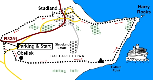
To view route as a dynamic Ordnance Survey map click here. Introduction: This walk to Old Harry Rocks is an easy circular ramble. It takes you along the flat, grassy ridge of Ballard Down, which, as the name suggests, is a chalk downland and part of the Purbeck Hills, to Old Harry Rocks. The views along this ridge are truly spectacular stretching over Poole Harbour on the north side and over Swanage on the south. There are a number of barrows, funerary monuments dating from the Late Neolithic/Late Bronze Age periods, on Ballard Down. They are Scheduled Ancient Monuments. The far point of the walk is Old Harry Rocks, or perhaps it should now be singular! At one time there was Old Harry and Old Harry's wife. However a storm in 1896 put paid to the wife so only Old Harry, a chalk sea stack remains. However there are various other interesting rock formations, which make this a spectacular section of coast. There are steep drops so beware the edges. The village of Studland occurs at about the half way point where there is a good pub, The Bankes Arms to take on sustenance. Alternatively, there are ample grassy spots above the cliffs for a picnic. Shortly after the start of the walk, you climb up the flanks of Ballard Down. This is quite a long steady pull worthy of the Amber marking but it is straightforward. At the top of the climb is an obelisk. Most of us expect obelisks to commemorate war dead or an individual but this particular one was erected in 1883 to celebrate the provision of a new supply of drinking water for Swanage. I think this gives an impression of how important and novel the provision of piped, fresh drinking water was in those days, something we today take for granted. This grand monument was taken down in 1941 to prevent it being used as a landmark by the German bombers. It was re-erected in 1952. The walk starts from a rough lay-by on the B3351 between Corfe Castle and Swanage. Assuming travel direction from Corfe Castle, after three miles from Corfe Castle, pass a large parking area on the left at a view point. The lay-by from which the walk start is a further three quarters of a mile on the left, not far past Purbeck Golf Club. Start: From the lay-by (SZ 017818), turn left and walk along the road a few yards. Note the walkers' gate in the lay-by is where you will return. Cross a stile on the right indicated by a public footpath fingerpost. Keep a look out for flying golf balls and time your crossing so as not to interfere with golfers and walk straight across the golf course to the left of a bench, then bear left into the trees. The route is marked with dark green arrows. Go through the trees and continue to follow the path downhill. It curves right, still going downhill. The last section was a little overgrown with bracken when I did the walk but it was possible to make out the route. Cross a stile which takes you on to the road (SZ 018815). Ignore the yellow arrow pointing right and turn left along the road. This road was quite busy so care is needed but you are only on it for about three hundred and fifty yards. Look out for a small rough lay-by on the left at which there is a bridleway sign pointing right (across the road). Turn right along the broad track of the bridleway, to climb the hill, passing a bridleway fingerpost pointing to Old Harry. The obelisk is soon in view. Head for it. The views over Swanage and Poole Harbour open up.
From the obelisk (SZ 022813), continue along the obvious broad track.
At the trig. point (SZ 044813), bear right to go through a walkers' gate and follow the path just to the right of the fence.
Follow the path round the point to see Old Harry and the other rock formations.
After the rocks, follow the clear main track to Studland. When you reach the tarmac road, turn right for Studland, passing public toilets and the Bankes Arms pub. Continue on the road and just as you reach the Pig Hotel, turn left at the road junction, along the road (SZ 036827). Pass the village pond, more public toilets, then turn right along the road following the sign for Poole and Bournemouth via Toll Ferry.
Just after passing the telephone box and bus stop, turn left, following the footpath yellow arrow. A sign in the wall says "Studholme" (SZ 034826). At the gates of the Studland Treking Centre, turn right to follow the yellow arrow and almost immediately to the left of some large gates. Follow the well marked path, ignoring some misleading turns to the right. Join a broad track at a 'T' junction and turn left (SZ 031826). Follow this until you come to another broad track on the right (There are a couple of tracks off to the right before this but ignore them.) Just after this, turn left following a yellow arrow and a a green arrow plus a sign "Heatherside Walls". Join a broad track and keep straight ahead following a row of houses on the left. After the houses, through a kissing gates and the route reverts to a more normal footpath. Keep straight following the yellow arrow but ensure you take the left hand, narrower path, not the tempting broader track to the right. On joining a broader bridleway, keep straight ahead, avoiding the turn to the right. As you gently climb, you will see the obelisk start to appear in the distance on the left and views over Poole Harbour appear to the right. Arrive at a junction with another path. There is a green National Trust arrow pointing right but you should keep straight ahead following the blue arrow. You start to follow the edge of the golf course. Follow the obvious path to its left hand side, clearly segregated from the course.
If you need to buy any hiking equipment/clothing before your trip see the Hiking Store All information on this site is given in good faith and no liability is accepted in respect of any damage, loss or injury which might result from acting on it.
| | |||||||||||||||||

.jpg)
.jpg)
.jpg)
%20View%20over%20Swanage.jpg)
%20View%20over%20Poole%20Harbout.jpg)
%20View%20over%20Studland%20Bay.jpg)
%20Ballard%20Down%20obelisk.jpg)
%20View%20back%20to%20obelisk%20with%20Godlingston%20Hill.jpg)
%20Ballard%20Down%20trig%20point%20with%20Swanage%20behind.jpg)
%20Approaching%20Old%20Harry%20Rocks.jpg)
%20Sea%20stacks%20at%20old%20Harry%20rocks.jpg)
%20Sea%20Stack%20at%20Old%20Harry%20Rocks.jpg)
%20Chalk%20cliffs%20at%20Old%20Harry%20rocks.jpg)
%20Old%20Harry.jpg)
%20Village%20pond%20at%20Studland.jpg)