
|
|
|
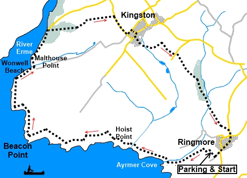
To view route as a dynamic Ordnance Survey map click here. Introduction: This scenic walk takes you from the pretty village of Ringmore to the equally pretty Kingston, along a stretch of the South West Coast Path. It includes a short section along the course of the River Erme, a very pretty and relatively quiet estuary with acres of golden sand. The river can be waded one hour either side of low tide. Unlike the much busier River Avon, a few miles further east, there is no ferry. Ringmore is an ancient village mentioned in the Domesday Book. There are thatched cottages, some as old as the 1600s. All Hallows Church and the Journey’s End pub date back to the 1200s. If you plan to make use of the pub at the end of your walk, check on the opening times before relying on it. Hours vary. Kingston too is an old unspoiled village containing the 16th century Dolphin Pub which could provide a useful lunch stop. The pub straddles the lane with its garden and outbuildings on one side and the main pub on the other. Again, check the opening times. The walk is straightforward but there are a couple of steep ascents/descents shortly after the start hence the amber traffic light above. The walk starts from the National Trust car park (minimal charge) in Ringmore. To get there, turn south west off the A379, just over a mile from Modbury, on to the B3392, signposted for “Ringmore 4 miles”. Follow the B3392 for two and a half miles and at St Ann’s Chapel, turn right for Ringmore. Start: Take the footpath leading out of the car park by the information board to Ayrmer Cove. At a ‘T’ junction of paths, turn left for the coast and at the coast path, turn right.
It is now simply a case of following the coast path for a while. There is a fairly steep climb up out of Ayrmer Cove.
Around a third of a mile further on, at the next cove (Westcombe Beach) there is a steep descent and an equally steep ascent which zig-zags a little to even out the climb a little. At the top is a National Trust sign and information board to inform you that you have arrived at the land belonging to Sobbiscombe Farm. Just beyond the board is a handy bench with good views (SX 632459) – which you might be grateful for after the climb!
At SX 629460 is a two way fingerpost. Continue in the direction of Wonwell.
Continue on the coast path until you reach more signs for Sobbiscombe Farm. The mouth of the River Erme is ahead. Across the estuary is Mothercombe Beach. From the signs, a concessionary path goes off to the right to Kingston. However ignore this and continue along the path alongside the River Erme. The path briefly crosses Wonwell Beach.
The path descends some steps out of pretty woodland at Wonwell Slipway. Turn right here. Join a tarmac lane and walk along it for no more than 50/60 yards. Turn right at a public footpath fingerpost for “Kingston 1¼ miles”.
The path emerges from the trees into a field and there is something of a fantastic “surprise view” to the left, across to Dartmoor. Follow the right hand boundary of the field to a stile in the opposite corner. Follow the right hand boundary of the next field and go through a walkers’ gate into a short stretch of walled lane. In the field beyond, follow the public footpath fingerpost direction across the middle of the field. At the far side of the field, bear left following the public footpath fingerpost and follow the right hand boundary to the road. Turn right. At the cross roads, turn left then first right. Pass (or enjoy!) the Dolphin Pub and at the road junction, turn right, then left by Rock Cottages. The road becomes a track and forks. Take the left fork. As the track bends to the right, there is a two way fingerpost. Follow “Ringmore 1½ miles”. You are now cross in a private garden where the grass is usually nicely mown. Follow the left hand boundary, exiting through the trees on a path indicated by a yellow arrow. At the end of the trees, cross a ‘V’ shaped stile and then follow the left hand boundary of the field. At the top of the field, turn right and in the same field, follow the left hand boundary. The footpath follows this route around the field to avoid crop damage. Cross a stile in the corner of the field and keep to the left in the next field. You should be able to see a fingerpost at the far side of the field. When you reach it, turn left along the tarmac lane and quickly right to follow another fingerpost for “Ringmore 1¼ miles” At the end of the first field, go through a walkers’ gate to join a broad track. Turn left and almost immediately right to follow it. There is a fingerpost with yellow arrows pointing your way. About three quarters of the way along the field, look out for a two way fingerpost. Turn left to follow the public footpath. Turn right at the end of the field to follow the left hand boundary, once more to avoid trampling the crops. Part way along the field, the path diverts left into the woods, indicated by a yellow arrow. Follow the obvious track through the woods and across some clearings, arriving at a ruined cottage. The path is to the right of the cottage, where it climbs gently through more trees. Just as you are about to exit the trees, a five bar gate blocks your progress. Turn right here through a walkers’ gate following the yellow arrow. The path climbs a steep banking. At the top, turn left through another walkers’ gate. Near the end of the field, go through a kissing gate and follow the left hand boundary of the field. Ringmore is now in sight. Two thirds of the way along the field, go left through a gate to follow the yellow arrow, to a walkers’ gate in the diagonally opposite corner. Through this, bear left to the road and turn right. Pass the church and turn right and follow the road back to the parking.
If you need to buy any hiking equipment/clothing before your trip see the Hiking Store All information on this site is given in good faith and no liability is accepted in respect of any damage, loss or injury which might result from acting on it.
| | |||||||||||||||

.jpg)
.jpg)
.jpg)
%20Ayrmer%20Cove.jpg)
%20Ayrmer%20Cove%20and%20Burgh%20Island.jpg)
%20Westcombe%20beach.jpg)
%20Fernicombe%20Beach.jpg)
%20Looking%20to%20Mothercombe%20Beach.jpg)
%20River%20Erme.jpg)
%20Walkers%20wading%20the%20River%20Erme.jpg)
%20Wild%20campion%20by%20footpath%20at%20Erme%20Mouth.jpg)
%20View%20over%20Wonwell%20Beach%20to%20Erme%20Mouth.jpg)
%20View%20to%20Dartmoor.jpg)
%20Church%20At%20Ringmore.jpg)