|
Postbridge
to Bellever Tor (Dartmoor)
|
Starting
point and OS Grid reference:

Dartmoor
National Park car park at Postbridge (SX 647789)
|
Ordnance
Survey Map
OL
28 - Dartmoor.
Buy this map from
List
of OS Maps
Commission from map sales is
used to fund the website, so keeping it free to use.
| |
Distance: 6 miles
| |
Traffic light rating:


(For explanation see My
Walks page)
| |


For advice on .gpx files see
My
Walks page
|

Click
the PDF logo above to give a printable version of this walk without the
photos.
|
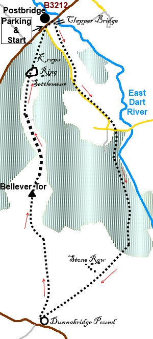
Introduction: This walk from Postbridge
takes you through the Bellever Forest run by the Forestry Commission to
Bellever Tor with its spectacular granite rock formations. The walk passes
the Laughter Man, an ancient standing stone at the end of what is left of a
double stone row and on the descent from Bellever Tor, you pass through an
area of the ancient Kraps Ring settlement dating back to the Bronze Age. A
number of posts have been stuck in the ground to mark the more interesting
features but even so, to the untrained eye, they are difficult to
appreciate. However, the hut circles can be discovered amongst the heather.
There are great views from the top of the Tor
and the sinister mass of Dartmoor Prison can be clearly seen.
At Postbridge is an impressive clapper
bridge, possibly from the 14th century; one of the largest on Dartmoor and a
magnet for tourists, as it is conveniently next to the road. There is a
small Post Office Store and the River Dart Hotel where sustenance can be
obtained before/after your walk and toilets at the National Park Centre,
where the walk starts.
Postbridge is on the B3212 between
Moretonhampstead and Princetown.
Start:
Leave the car park (SX 647789) and turn left along the B3212. After passing
the Post Office our route is on the right on the public bridleway before the
road bridge. However, before starting the walk proper, a “must see” is
the ancient clapper bridge over the East Dart River which is clearly visible
on the right. This is one of Dartmoor’s oldest clapper bridges and
probably dates back to the 13th or 14th centuries and built so that
packhorses could cross the river.
Return to the
bridleway on the other side of the road bridge, now on the left. Follow the
bridleway to the left of a plantation, until you reach a broad stony track
close to the minor road (SX 650780). Go more or less straight ahead to head
for a second plantation on the right. The bridleway runs parallel with the
road at this point.
To
view route as a dynamic Ordnance Survey
map click here.
%20Clapper%20bridge.jpg)
%20View%20back%20to%20Clapper%20Bridge.jpg)
When the
bridleway drops down to the road, turn left and follow it down past some
houses. As it bends to the right, take the bridleway off to the left, just
before the cattle grid (SX 655774).
At the corner of the Bellever Forest, turn
right on the broad track. You are passing through a pay and display car park
area which could be an alternative if the National Park Centre car park was
full.
Stay on the main track past the toilets and
information boards. When it forks at the corner where there are picnic
tables, take the left fork to the gate.
Go through the gate (and Take the track
straight ahead, ignoring the track to the right. On the left at this point
is a nice view of the East Dart River.
%20View%20of%20river%20Dart.jpg)
When the track splits, the left fork going to
Laughter Hole House, take the right fork for Laughter Hole Farm. Stay on the
track until it starts to turn right. Ignore this turn and carry on straight
ahead through the gate following the fingerpost marked simply as “Path”.
Just after passing a stone barn, come to a
gate. Once through it, the track splits (SX
658759). Take the right hand path following the fingerpost “Public
Bridlepath Country Road B3357 at Huccerby Cottage”.
At the top of a small rise, there is a track
branching off to the right but ignore this and keep straight ahead for the
gate, where there is a three way fingerpost. Follow the arm for Dunnabridge
Pound.
You are now in open countryside and over to
the right peeping over a wall is a standing stone (SX 652754), actually the
end of a stone row, known as the Laughter Man. To its right is Laughter Tor.
%20Laughter%20Man%20Standing%20Stone.jpg)
Continue along the track for just over half a
mile to reach Dunnabridge Pound (SX 646747) .This is a large circle of stone
wall just before you get to a farm. It does not look particularly exciting
but its origins go back to the Bronze Age. It is also about dead centre of
the Dartmoor National Park.
From the gate on the track, turn around and
bear left following the fingerpost for Bellever Tor and Postbridge. The path
runs along the right hand side of a wall. Follow this wall along turning
right to follow its 90° right turn until you reach a fingerpost at a left
hand 90° turn of the wall (SX 647750). The path actually cuts across to
this point but is not clear on the ground and if you follow the wall you
cannot go far wrong. Turn left at the fingerpost and follow the wall to your
left, heading for Bellever Tor straight ahead.
According to the OS map, the footpath goes
across by the trees but the favoured route to the Tor is to stay with the
wall to a gate, go through it and follow a broad track bending right to the
Tor.
%20Bellever%20Tor.jpg)
There is a “notch” in the Tor which is
your aiming point.
As you approach the Tor, the trig. point (SX
646764) becomes clear.
%20Eroded%20Rocks%20at%20Bellever%20Tor.jpg)
%20Rock%20Formations%20at%20Bellever%20Tor.jpg)
%20Bellever%20Tor%20Trig%20Point.jpg)
%20View%20from%20trig%20point.jpg)
Continuation of the walk is in effect through
the “notch”. Follow the obvious path which runs between the two
plantations. As you descend from the Tor and the ground levels out , the
official public footpath goes right into the plantation but I preferred to
stick to the more open land between the plantations. This is Access Land so
you can walk where you like.
On the more level section, if you look back
towards the Tor, you may be able to make out the remains of the walls of an
ancient settlement which is marked on the OS map.
As you progress between the plantations,
there are other ancient remains to see, not least some hut circles and a
small stone row. There are a number of posts which mark many of these. One
of my photos is of a scene with a hawthorn tree in blossom. I took it
because I likes the picture but when I got closer, I realised the tree was
actually growing in a hut circle and was I think an outer hut of the Kraps
Ring Settlement, shown on the OS map.
%20Stone%20Row.jpg)
%20View%20north.jpg)
Continue to the end of the open area between
the plantations and follow the obvious footpath at the end.
After crossing a broad track, make your way down the firebreak,
coming out at a car park – you have to climb over a “stile” of half
logs in the fence.
Turn right at the road to return to the
National Park centre.
If you need to buy any
hiking equipment/clothing before your trip see the Hiking
Store
All information on this
site is given in good faith and no liability is accepted in respect of any
damage, loss or injury which might result from acting on it.
|


.jpg)
.jpg)
.jpg)