|
East
Prawle to Hallsands and Start Point
|
Starting
point and OS Grid reference:

East
Prawle village green – car parking with voluntary
contribution (SX 781364)
|
Ordnance
Survey Map
OL20
South Devon – Brixham to Newton Ferrers.
Buy this map from
List
of OS Maps
Commission from map sales is
used to fund the website, so keeping it free to use.
| |
Distance: 8.5
miles
| |
Traffic light rating:

(For explanation see My
Walks page)
| |


For advice on .gpx files see
My
Walks page
|

Click
the PDF logo above to give a printable version of this walk without the
photos.
|
To
view route as a dynamic Ordnance Survey map click here.
Introduction:
This walk from East Prawle utilises
the ancient bridleways cross country to Hallsands then returns via the Coast
Path taking in Start Point, with its lighthouse, and Lannacombe. The
bridleways can be muddy after wet weather but are festooned with wild
flowers in spring/early summer. On various gate posts along the route of the
Coast Path are labels giving the Ordnance Survey reference, which you can
relate to the map to monitor progress.
The walk along the
coast is particularly attractive, with good views around Start Bay across
Slapton Sands towards the River Dart. From Start Point back to East Prawle,
the coast is more rugged with interesting bays.
Overall, it is an
easy walk but with a steep walk up a field at the end.
The village of
Hallsands has an especially interesting and tragic history. This is very
fully explained by information boards at the site but in a nutshell goes as
follows. In 1894, the Royal navy wanted to extend Devonport Dockyard, for
which they needed vast quantities of shingle (presumably for concrete). In
1897, they started dredging at Hallsands. Eventually, the beach level had
dropped between 7 and 12 feet, undermining the cliffs. The winters of
1902/03 produced major storms which damaged the sea wall and houses. The pub
collapsed. By 1917, the village had been destroyed and virtually abandoned.
To make matter worse, it seems that the Government cheated the villagers out
of compensation. Not much of the village now remains but it is interesting
to see its precarious position.
Our starting point,
East Prawle, is a sprawling yet picturesque village with a village green at
the centre where you can park (voluntary contributions). There is a pub, a
useful village store and toilets around the green.
There are a number
of ways to get to East Prawle, all via single track roads with passing
places but the least stressful way and easiest to find, is to turn south off
the A379 near Stokenham, at the mini roundabout at Carehouse Cross (SX
804428) and follow the signs.
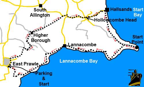
Start:
From East Prawle village green (SX 781364), walk down the road in front of
the Pig’s Nose pub and at the junction turn left then first right. Follow
the lane passing Town Farm and a phone box next to a bench then, as the land
bends to the left, take the bridleway to the right along a broad track (SX
781367).
%20Village%20green%20at%20East%20Prawle.jpg)
At a junction of
broad bridleways (SX 785368), turn left and when this track appears to go
into a field, keep straight ahead.
The bridleway, with
hedges either side, opens into a cultivated field and at the end of it, turn
right along a tarmac lane signposted “Lannacombe Green 1½ miles” and
“Woodcombe Sand ¾ mile”.
Follow the lane
round one sharp left hand bend and at the next bend (sharp right), leave the
road straight ahead, following the public footpath/bridleway fingerpost.
As the
footpath/bridleway bends to the right, keep straight ahead following the
fingerpost for “Lannacombe Green 1¼ miles”. Go through the gate then
immediately through another gate. The path then goes diagonally downwards,
passing to the left of a pond.
Pass the pond, go
through the gate and turn right, following the public bridleway fingerpost.
At the next
junction of bridleways, turn left and take the first right (SX 789377). This
dog-leg, a legal diversion round the dwelling Higher Borough, is clearly
indicated by green bridleway signs. As you come behind the dwelling, the
track divides and you want the right hand fork for about 75 yards, before
turning left (SX 790378) to follow the green bridleway sign.
Ignore a track
which goes off to the left and follow the blue bridleway arrow along the
right hand side of the field. The next section of this walk is clearly
indicated by the blue bridleway arrows which you should continue to follow,
descending a pretty valley until you reach a tarmac lane (SX 801383). Turn
right here.
Stay on the lane to
a junction and turn right following the road signs for Hallsands and Start
point, ignoring the right turn to Lannacombe (although if you wanted to, you
could shorten the walk here by walking down the road to Lannacombe to pick
up the Coast Path). Shortly after passing the cottages at Hollowcombe,
arrive at the crossroads at Hollowcombe Head and go straight ahead
signposted “South Hallsands”. Follow the road to its end and see what is
left of Hallsands village from the viewing platform and read the interesting
information display (SX 818386).
%20Hallsands.jpg)
%20Looking%20Back%20at%20Hallsands.jpg)
%20View%20Round%20Start%20Bay.JPG)
%20Approaching%20Start%20Point.JPG)
Returning from the
viewing platform, turn left to follow the Coast Path to Start Point (SX
329372). The lighthouse there is sometimes open to the public.
%20Start%20Point%20Lighthouse.JPG)
From here, simply
follow the well marked Coast path west. You pass Mattiscombe Sand (SX
817369), then Lannacombe (SX 801372), both attractive little bays with small
beaches. At Lannacombe, you pass a fingerpost which tells you it is 2½
miles to Prawle Point (though this walk does not go that far). There are old
mill stones lying by the Coast Path at Lannacombe which give a clue as to
its history.
%20Mattiscombe%20Sands.JPG)
%20Lannacombe.jpg)
You pass an
imposing house at Ivy Cove. There is a split in the path here but you want
the right hand fork in front of the house.
Pass Malecombe
House (SX 791363) with its mock Tudor frontage, then go through a walkers’
gate and across a field. The path bends right then left into the next field
and at the end of that second field, arrive at a three-way fingerpost. Go
straight ahead following “East Prawle ½ mile”.
As the path rises,
look out for a post on the left with blue arrows indicating the bridleway
fore and aft but also a yellow footpath arrow pointing right (SX 784361). Go
right over a rather awkward stone stile. The path leads to the top right
hand corner of the field where an equally awkward stile exits the field into
a walled lane. Turn right here.
After passing the
house “Bayfield”, turn right at the narrow tarmac road. Follow this road
until it returns you to East Prawle village green.
If you need to buy any
hiking equipment/clothing before your trip see the Hiking
Store
All information on this
site is given in good faith and no liability is accepted in respect of any
damage, loss or injury which might result from acting on it.
|


.jpg)
.jpg)
.jpg)