|
Chagford
to Fingle Bridge (Dartmoor)
|
Starting
point and OS Grid reference:

Chagford
– Pay and display car park (SX 702874)
|
Ordnance
Survey Map
OL 28 -
Dartmoor.
Buy this map from
List
of OS Maps
Commission from map sales is
used to fund the website, so keeping it free to use.
| |
Distance: 9.3 miles
| |
Traffic light rating:


(For explanation see My
Walks page)
| |


For advice on .gpx files see
My
Walks page
|

Click
the PDF logo above to give a printable version of this walk without the
photos.
|
To
view route as a dynamic Ordnance Survey map click here.
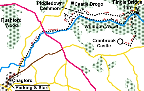
Introduction:
This walk from Chagford explores part
of the Teign River valley along very easy to follow paths/tracks. The
majority is fairly level, apart from a relatively moderate climb to
Cranbrook Castle, if you decide to investigate this, and some steep steps
around a rocky bluff – see penultimate paragraph. Cranbrook Castle
ramparts are fairly clearly visible although bracken was starting to grow
when I visited, obscuring the outlines.
Chagford itself is a lovely and ancient
“Stannary” town - meaning it was the administrative and judicial centre
of the local tin mining area. It is well worth a look round.
The initial riverside part of this walk is
very attractive and then you climb gently to a higher level path looking
down on what looks like an in penetrable valley although, as you will
subsequently discover, there are two well used paths alongside the river.
From the higher level paths are superb views along the valley and over
Chagford in the distance. This stretch of the walk crosses the delightfully
named Piddledown Common.
A bonus is an opportunity to lunch at the
Fingle Bridge Inn, not surprisingly, by Fingle Bridge. The Inn has some very
scenically positioned outside tables next to the river. If you picnic
instead, there are numerous benches along the route.
There is a chance of seeing various wildlife
including trout, various butterflies and fallow deer.
Although I include GPS routes, much of this
walk is under trees so GPS receivers are largely useless, at least when the
trees are in leaf. However, the paths are so easy to follow, use of GPS is
hardly needed.
As an alternative to starting from Chagford,
you could start this circular walk from Fingle Bridge, where there is free
parking. However the roads to this spot are very narrow and single track.
The walk starts from the modestly priced pay
and display car park just off the High Street near Chagford Church. It is
signposted and try not to overshoot/miss it, as the roads beyond are very
narrow and quite congested with parked cars near the town. To get to
Chagford, take the B3206 off the A382 between Whiddon Down (just off the
A30) and Moretonhampstead.
Start:
From the car park, walk back along the High Street and turn right at The
Square and walk north east along the B3206 for about a quarter of a mile.
Turn left on a country lane signposted for Swimming Pool (SX 704880).
%20Chagford%20Church.jpg)
%20Riverside%20meadow.jpg)
After just over another quarter of a mile,
turn right at Rushford Mill Farm (SX
706885) and through the farmyard, following the fingerpost for
Drewsteighnton and Fingle. Follow the right hand field boundary next to the
river until you reach an old stone gatepost at which point the bath veers
slightly left to cut off the corner.
At a three way fingerpost, where the left
fork goes to Sandy Park, keep straight ahead on the riverside path following
the fingerpost for “Road at Dogmarsh Bridge”.
On reaching the road (SX 713894), cross
straight over to enter the National Trust land “Castle Drogo Estate” and
continue to follow the river. At a footbridge (do not cross), there is a
three way fingerpost (SX 722896). Turn left for “Hunters Path” and
“Road Near Castle Drogo”.
The path climbs through the trees and comes
out on the drive to Gib House. Turn right following the public footpath
fingerpost. Shortly after that, turn right on a tarmac drive again following
a public footpath fingerpost.
Continue along this drive and look out for a
three way fingerpost on the right (SX
720900). Turn right to follow the path for “Hunters Path Public
Bridleway”. Nearer the gate is another fingerpost for “Castle Drogo 0.5
mile” and “Fingle Bridge 1.5 miles”.
Stay on the main path for Fingle Bridge
ignoring various left turns taking you to Castle Drogo (unless you want to
see this National Trust property).
%20View%20towards%20Chagford.jpg)
At SX 728899 is a dramatic viewpoint of the
Teign Valley.
%20View%20over%20the%20teign%20valley.jpg)
At a junction by a bench “Ronnies Seat”
turn right for “Fingle Bridge Public Bridlepath”. At the road (SX
743910) turn right and walk down to the bridge.
%20Fingle%20Bridge.jpg)
%20Fingle%20Bridge%20Inn.jpg)
Here you have the option to visit Cranbrook
Castle, an Iron Age hill fort. My directions assume you will but otherwise
at the bridge, turn right to follow the river. There are paths on both
sides. For no particular reason, I chose the right hand (north) path.
To visit Cranbrook Castle, cross Fingle
Bridge and enter the National Trust land;
Charles and Hannicombe Woods. Turn left at this sign and after a few
yards, turn right following the fingerpost “Public Byeway for Cranbrook
Down” (SX 743899). The broad stony byeway is an easy route to follow if a
little steep. Stay on it, ignoring any turns off, in particular on the right
the Lower Deerstalkers Path and later the Upper Deerstalkers Path. Point of
interest - opposite the Lower Deerstalkers Path is a large stone with a
cross carved in its side. I am not sure of its significance but I have seen
similar stones before which purport to have been used as a resting place for
coffins, on the journey to burial.
%20View%20along%20the%20Teign%20Valley.jpg)
%20Stone%20with%20cross.jpg)
The track starts to level out. Continue until
you reach a fingerpost on the right “Public Footpath to “Cranbrook
Castle (Iron Age Ramparts)” (SX 742889). Turn right. The ramparts are
visible although when I visited, in early summer, bracken was growing well
and beginning to obscure the outlines.
After visiting Cranbrook Castle, retrace your
steps to Fingle Bridge, cross it and turn left along the right hand (north)
riverbank, following the fingerpost for “Fishermans Path” and
“Dogmarsh Bridge, Chagford, Castle Drogo Shop and Café”.
%20Riverside%20path.jpg)
At one point, you have to climb then descend
some steep steps to pass a rocky outcrop but there is a handrail to assist
(if you think this might be a problem, take the left (south bank) path from
Fingle Bridge).
%20Weir%20with%20Fish%20Ladder.jpg)
Shortly after passing a weir with a fish
ladder arrangement, you reach the footbridge where you turned off on the
outward journey. Retrace your steps to Chagford.
If you need to buy any
hiking equipment/clothing before your trip see the Hiking
Store
All information on this
site is given in good faith and no liability is accepted in respect of any
damage, loss or injury which might result from acting on it.
|


.jpg)
.jpg)
.jpg)