
|
|
|
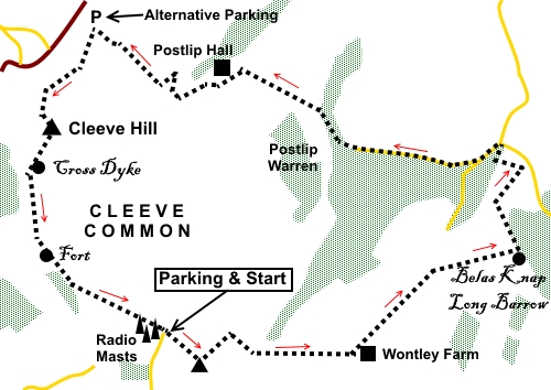
To view route as a dynamic Ordnance Survey map click here. Introduction: Cleeve Hill on Cleeve Common is the highest point in the Cotswolds and Gloucestershire at 330 metres. It has three Scheduled Ancient Monuments, although I only saw two, the remains of Cross Dyke and the Hill Fort. The Ring eluded me! Cleeve Common is also a Site of Special Scientific Interest, home to rare plants and varied wildlife and a designated Area of Outstanding Natural Beauty. At one time, Cleeve Hill was known as Cleeve Cloud. There are various vantage points on this walk from which there are tremendous long distance views. This walk includes Belas Knap Long Barrow. Belas Knap Long Barrow is 5500 years old. The remains of at least 38 people were discovered, during excavations in the 1860s, who were estimated to have died between 3600 and 3700 BC. Much of the walk is on unambiguous paths/tracks but on Cleve Common itself, people have wandered all over and there are many trodden paths. Giving directions in these circumstances is difficult but I will do my best. Overall, the going is easy but there is one short steep section up Cleeve Hill itself which warrants an “amber” marking. The walk starts at a free public parking area by prominent radio masts. At various points during the walk, you can see these, so helping your orientation. To get there, turn north off the A436 just east of Andoversford, following the signs for Whittington, then follow signs for Cleve Hill. Alternatively, start the walk at the car park B4632 at Woodmancote, Bishop’s Cleve (SO 989271). Start: From the car parking (SO 994248), continue to the end of the road and turn right through a walkers’ gate. Follow the fence on the right until you reach the trig. point at SO 997246. There are good views here over towards the Severn Valley.
With the trig. point behind you, walk away from it at 90° to the fence, aiming to the right of the larger patch of bushes/gorse ahead of you, for 0.2 of a mile. As you get to it, walk down the right hand side of it. At the end of the patch of bushes/gorse, just before the hill starts to descend, turn right at 90° along a well flattened grassy track (SO 999248). Keep straight ahead on this track, passing a post with a yellow arrow for the Winchcombe Way. The track leads to a gate. Go through this and follow the broad track as it curves left. There are excellent views along here to the North.
The track arrives at the derelict Wontley Farm (SP 006247). Turn left here to follow the “Restricted Byway” “Winchcombe Way” fingerpost. Just over half a mile after Wontley Farm, as the main track bends left, turn right to follow a Public Footpath fingerpost for the “Cotswold Way” and “Belas Knap ½ mile” and “Winchcombe 3 miles”. You arrive at the Belas Knap Long Barrow which you see for some distance in advance, characterised by one of the stone openings in the grassy mound. After exploring the barrow, continue the route via the kissing gate, just after crossing a stone stile, next to the information board.
Initially, the footpath goes through trees but just after coming out of the trees, look through a gap on the right and you can see Sudeley Castle and a little further on, Winchcombe too.
Go through another kissing gate and follow the right hand boundary of the field, down the hill. At the bottom of the field, turn left to follow the right hand boundary again, along by the trees. This is the correct route, not a diagonal across the centre of the field! The path drops down to a kissing gate where you turn right through the trees (SP 019261). Just before reaching the road and rather than having to walk along it, turn left to follow a yellow arrow to follow the Cotswold Way. When you do finally join the road, at a ‘T’ junction, turn left to follow the road sign for “Corndean Lane” and “West Downs”. Stay on the road, ignoring a left fork signed “Farm Access Only”. There are excellent views over Winchcombe on this stretch of road.
At the end of the road, go through a walkers’/bridleway gate, keeping straight ahead for the “Cotswold Way”. After the first field, the path drops down through woods and crosses a stream via a footbridge. It then opens into a large field where you follow the very clearly walked path along the left hand boundary. Almost at the top of the field, go through a gate and turn right to follow the blue bridleway arrow for the Cotswold Way. The route is now a broad track. You approach a farmyard and the route is straight through it. However, if it happens to be full of livestock and/or mucky, an alternative path has thoughtfully been provided on the left. You arrive at the impressive Postlip Hall. Just before the hall, turn left via a walkers’/bridleway gate indicated by a blue bridleway arrow for the Cotswold Way plus a green marker for the Isbourne Way (SP 000268).
Follow the boundary wall of Postlip Hall and at some stables, keep straight ahead following Cotswold Way signs. When the Postlip Hall boundary wall curves away from you and the Cotswold Way follows it round, turn left over a stile, following a yellow arrow and an Isbourne Way marker.
The next section is easy to follow, marked by well trodden turf and yellow arrows, until you reach a broad track, after crossing a stile (SO 995269). Turn right along the track and almost immediately, fork left to climb the hill. Things now get a little tricky as there are so many paths which have been created by people wandering “off piste” and these may differ over time. In many ways, it does not matter too much which way you go as long as you keep going up. However when I did the walk, you join a broad track. Turn left. After not very far (150 yards ish) take a narrower path off to the right (SO 994267) and after a few yards, a fainter track on the right. Keep ascending, just to the right of what look like spoil heaps. Continue up the hill, crossing other broad tracks. As you reach the top, bear left through some patches of gorse. Ahead of you is the town of Bishop’s Cleeve.
Arrive at another car park, which is an alternative point from which to start this walk. Turn left here along the right hand (lower) of two obvious paths. A post with a yellow arrow soon comes into view. Stay on this path as it curves round the hill. There are a number of Cotswold Way yellow arrows on posts to indicate the way. At SO 985265, the path starts to climb steeply to the trig. point. There are good views over Cheltenham. By the trig. point is a (not too clear) topograph which identifies various landmarks.
Turn right at the trig. point and when the path forks, keep to the right, to follow the path round the edge of the plateau. At SO 985261, you walk through the remains of the ancient earthwork Cross Dike and further on at SO 985256 similar remains of an ancient fort. Here too is a bench dedicated to one Ron Brazil. The path forks here. Take the left fork.
The radio masts which marked the start of your walk are ahead of you. Simply take the obvious path to return to them and the car park, passing at SO 991251 the Prestbury Hill reserve, a butterfly conservation project. If you need to buy any hiking equipment/clothing before your trip see the Hiking Store All information on this site is given in good faith and no liability is accepted in respect of any damage, loss or injury which might result from acting on it.
| | |||||||||||||||||

.jpg)
.jpg)
.jpg)
%20Radio%20masts%20and%20car%20park%20at%20start.jpg)
%20Trig%20point%20near%20start%20of%20walk.jpg)
%20Winchcombe%20Way%20sign.jpg)
%20View%20North.jpg)
%20Approaching%20Belas%20Knap.jpg)
%20Inside%20Belas%20Knap.jpg)
%20View%20to%20Sudeley%20Castle.jpg)
%20Telephoto%20shot%20of%20Sudeley%20Castle.jpg)
%20View%20over%20Winchcombe.jpg)
%20Postlip%20Hall.jpg)
%20Isbourne%20Way%20sign.jpg)
%20View%20over%20Bishop's%20Cleeve.jpg)
%20Topograpg%20and%20trig%20point%20on%20Cleeve%20Hill.jpg)
%20Ditch%20remains%20at%20ancient%20fort%20site.jpg)